
Construction of Blocking Pattern, GFS Bullish
Construction of a block is an important part of the overall weather picture that is developing for the northeast. It involves many facets and in this case it may even involve a rare January tropical storm or subtropical storm that is developing in the Southwest Atlantic. I posted about it earlier that this the first tropical system in January since 1978. Those of you with long enough memories know how January of 1978 turned out for the the northeast.
Take look a the satellite loop below and you can see the system moving away from the Bahamas and models are forecasting this to intensify into at least a major storm and possibly a tropical system of some sort. It will impact the construction of the Greenland block.

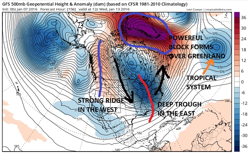
Now such construction is key because the block will lock the vortex in place in Eastern Canada. It will also force a disturbance rotating around the vortex to dive into the northeast and possibly create low pressure development along the east coast. We still have a long way to go here to see how this turns out but model trends which began on Tuesday and continued today seem to be going in this direction.
Here is the latest overnight weather video regarding the GFS, the construction of the Greenland block, the subtropical storm, and other factors that will move this process along.
I said yesterday and last night that i did not believe the GFS trying to amplify a southern system to create this scenario. This is all going to be a function of the strong northern part of the jet stream. How a diving disturbance into the midwest plays out will be one of many keys here.
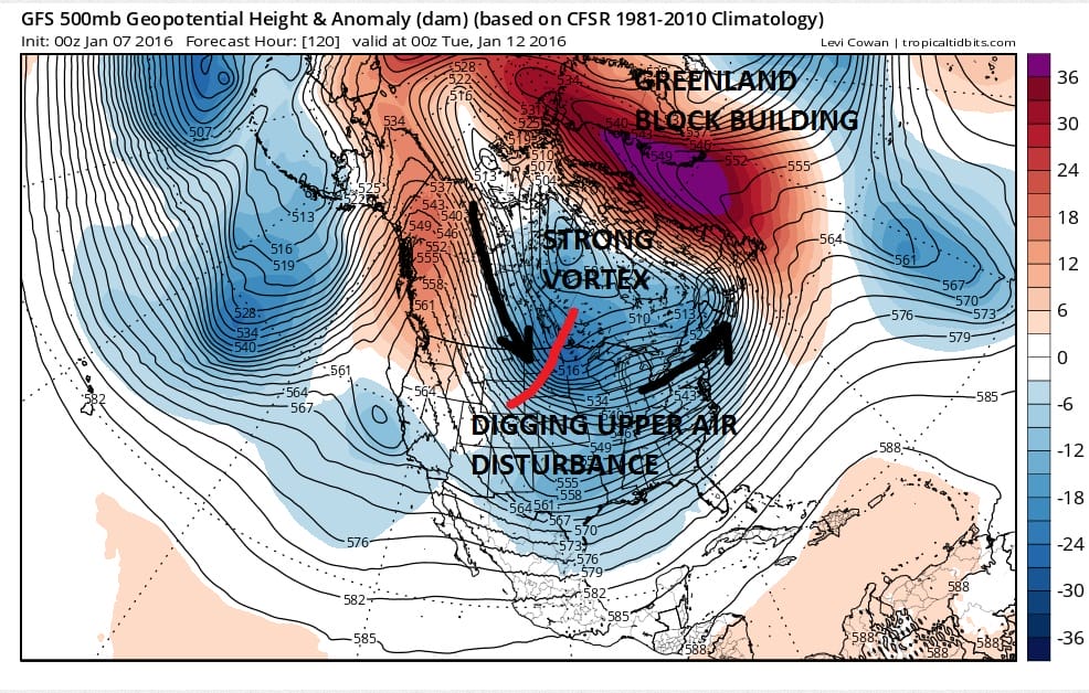
You can see it here on the map with the red line showing the diving upper air disturbance. It has no place to go but to dig southeast and sharpen as it swings toward the east coast. The developing block is holding the vortex in place which forces the trough to sharpen and intensify even further as it swings east. This is the scenario that needs to play out for any serious development to occur. There are also alot of variables here. The trough could take longer to deepen and swing around and that could force the low to develop further east. The further south the low starts out the more bullish it is for snow in the northeast particularly from New York City north and east. Other issues would include development being so close that by the time it gets going, all the precipitation would get going too late except for Southern and Southeastern New England. These factors will be among many that will need to be evaluated in the coming days. Cold air will be entrenched in the area so this becomes basically a snow or nothing situation.

The surface map that goes with this. DO NOT FOCUS ON THE LITERAL PRINT as this is going to change over time. We have a long long way to go yet to see how this all plays out. However the GFS model at least is following along with the European’s earlier view so we need to respect that trend. More adjustments in this scenario are going to come over the next several days.
Another important key to this will be the weekend storm system. How strong that storm gets is important because it acts as a mechanism to move the trough position further east. This is crucial because you can have all this blocking and all this energy, and if the trough is too far west or too far east you wind up with rain or you wind up with nothing. It is a very fine line that needs to be walked.
NATIONAL WEATHER SERVICE SNOW FORECASTS
LATEST JOESTRADAMUS ON THE LONG RANGE
Weather App

Winter is here! Don’t be without Meteorologist Joe Cioffi’s weather app. It is a complete weather app to suit your forecast needs. All the weather information you need is right on your phone. Android or I-phone, use it to keep track of all the latest weather information and forecasts. This weather app is also free of advertising so you don’t have to worry about security issues with your device. An accurate forecast and no worries that your device is being compromised.
Use it in conjunction with my website and my facebook and twitterand you have complete weather coverage of all the latest weather and the long range outlook. The website has been redone and upgraded. Its easy to use and everything is archived so you can see how well Joe does or doesn’t do when it comes to forecasts and outlooks.
Just click on the google play button or the apple store button on the sidebar for my app which is onMy Weather Concierge. Download the app for free. Subscribe to my forecasts on an ad free environment for just 99 cents a month.
Get my forecasts in the palm of your hand for less than the cost of a cup of Joe!
