
Confusing Models With Storm Signals
Confusing Models
By now you may have figured out that I have been avoiding openly discussing what has been circulating around social media circles regarding next weekend. Yes storms signals are flashing again. And yes those signals are there but models have been very confusing about specifics. Run to run has been a nightmare as models flip back and forth in many directions. Of the models the European seems to be the most consistent but let me back up for a moment to go over a few things.
Oscillation Indexes Not Confusing
First off what is not confusing are the signals that the oscillation signals are flashing. Let me explain. These indexes basically measure oscillations or movements between high pressure and low pressure in certain geographic areas. When high pressure dominates the high latitudes and areas like Greenland; this is the North Atlantic Oscillation. When this index goes negative in value it is telling us that pressures are lower south of the arctic region. This favors storminess across the mid latitudes with higher pressures to the north. Cold air gets displaced southward. Such is the condition we find ourselves this week and beyond.
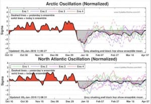
This graphic is the NAO nor North Atlantic Oscillation forecast. What we are seeing is that the index is forecast to go sharply negative over the next 10 days. In fact it is going to an extreme reading. This is clearly flashing a storm signal in the eastern US. This creates blocking in the atmosphere that can lock cold air across the Northeast and midwest and shift the storm track to the south. This is a storm pattern favorable for snow. This is coupled with another oscillation index that measures the conditions in the Arctic or the Arctic Oscillation. This index is going also negative to an extreme level.
When the Arctic Oscillation is negative it means cold air is displaced southward into Canada and the Eastern United States. There are 2 other important indexes we look at. One is the Pacific North America index or PNA. When that index is positive it means that there is a big ridge of high pressure in the west. This allows cold air from the arctic to move southeastward into Canada and the US. This index is forecast to rise to an extreme positive reading and is forecast to remain so.
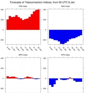
The last index we will look at is the Eastern Pacific Oscillation which is like the NAO for the Pacific.When it is negative (and it is) it favors cold and snow in the east. This index is negative as well. So when it comes to the indexes, they are flashing that conditions are favorable for a possible winter storm.
NOW THE CONFUSING PART
The confusing part are the models which go from one run to another showing a fierce storm off the mid Atlantic/Northeast coast one run and nothing the next. Such is the GFS model. The European has been more consistent with this and the GFS all over the place.
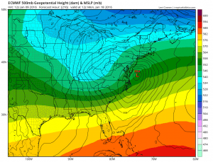
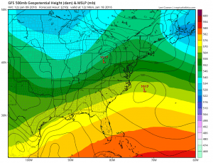
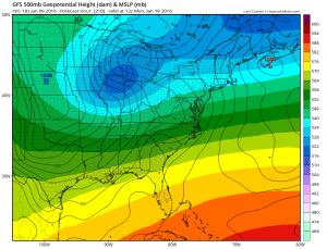
The maps are the European from this afternoon and the last 2 runs of the GFS, the bottom is the most current run. You can see how the maps are different. The colors represent the structure of the upper air jet stream pattern and you can see how different they are from every run. This has been the case for the last several days ever since this idea appeared on the models. When things are this confusing I usual step aside and wait for the models to clear up and become more consistent. Right now the European seems to be the most consistent of the bunch which is probably a positive sign for winter weather lovers. However let me caution you that just because these signals are flashing for next weekend, does not mean that a storm will form or take a favorable track, or develop to some ridiculous intensity. Could that happen? Sure it could. Could this wind up being much ado about nothing? Absolutely. Signals flashed for this weekend which were correct except we are seeing a low tracking from the Gulf States to Buffalo! In other words, you could have all these things screaming big snowstorm, but if the short range isn’t just right, it won’t happen. There is a lot of energy running around and models are having a rough time figuring out which one of these disturbances is the right one to focus on. Is it the first system? Or is it the second? And we have a northern jet stream playing into this as well. How much cold air will we have? Where would a storm (if any) track?
It seems to me that at this point, it is simply wise to just let this all settle itself and we should wait to see at least some consistent model runs, say 3 or 4 in a row doing the same thing before we rush out to buy liquor and cigars (not into the milk and bread thing). So in the meantime relax and lets get through the big rain and wind of Sunday with temps reaching the 60s before we start worrying about next weekend.
For more check my video from earlier regarding the GFS run from last night
NATIONAL WEATHER SERVICE SNOW FORECASTS
LATEST JOESTRADAMUS ON THE LONG RANGE
Weather App

Winter is here! Don’t be without Meteorologist Joe Cioffi’s weather app. It is a complete weather app to suit your forecast needs. All the weather information you need is right on your phone. Android or I-phone, use it to keep track of all the latest weather information and forecasts. This weather app is also free of advertising so you don’t have to worry about security issues with your device. An accurate forecast and no worries that your device is being compromised.
Use it in conjunction with my website and my facebook and twitterand you have complete weather coverage of all the latest weather and the long range outlook. The website has been redone and upgraded. Its easy to use and everything is archived so you can see how well Joe does or doesn’t do when it comes to forecasts and outlooks.
Just click on the google play button or the apple store button on the sidebar for my app which is onMy Weather Concierge. Download the app for free. Subscribe to my forecasts on an ad free environment for just 99 cents a month.
Get my forecasts in the palm of your hand for less than the cost of a cup of Joe!
![]()