Colder Weather Mid November On Course JOESTRADAMUS
Colder Weather Mid November On Course JOESTRADAMUS
Everything seems to be pointing to a Mid November weather pattern flip that will trend to a colder than average regime across the Eastern United States. The longer range weather indicators continue to point strongly in this direction.
Arctic Oscillation
There as been an almost unprecedented warming across the polar region over the past week that has set this all in motion. The Arctic Oscillation which is a measure of pressure changes across the Arctic regions. When the Arctic Oscillation is negative it is due to higher pressures across the polar regions. This tends to displace polar air southward into the middle latitudes. The index has been negative through much of October and is forecast to remain negative into the first half of November.
North Atlantic Oscillation
This is the same concept of the Arctic Oscillation on the North Atlantic side. This is more commonly referred to as the Greenland Block which creates the displacement of cold air from the North Atlantic into the Northeast United States. When the index is negative it weakens the winds across the North Atlantic. This allows cold air to build in Eastern Canada which spreads southward into the Eastern United States.
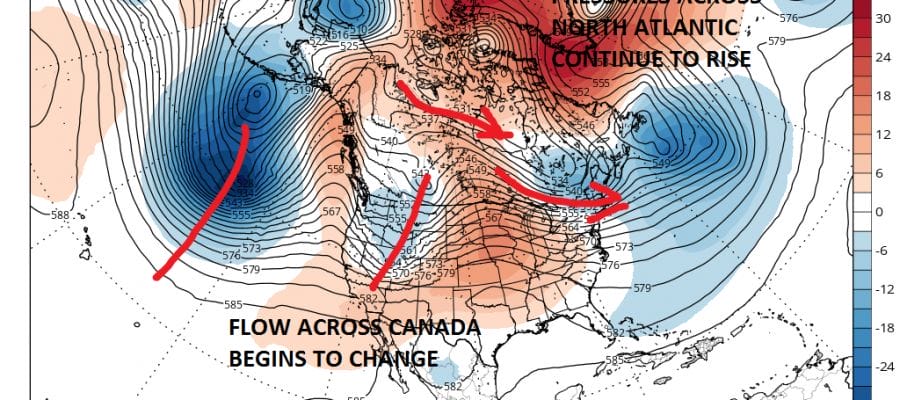
One of the missing ingredients in all this as been the state of the Pacific which has not been favorable for cold air to cross the polar regions and come into the United States. Today’s GFS at day 7 which is next Saturday November 5th. The state of the North Atlantic Oscillation being negative keeps it a little cooler in the Northeast US than it otherwise would be.
COLDER WEATHER REMAINS ELUSIVE THIS WEEK
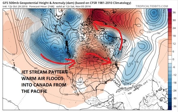
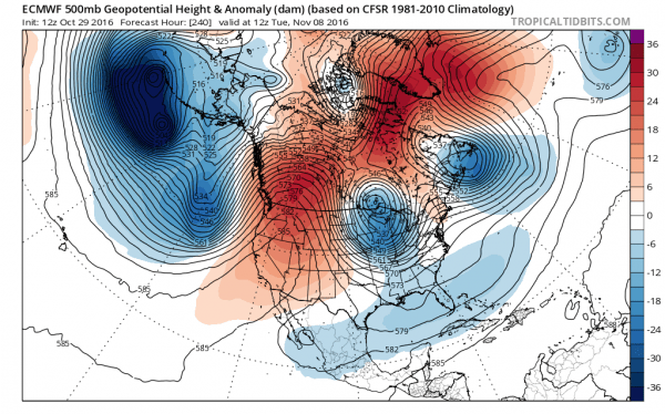
However beginning on Day 8 we see a large scale change in the overall pattern in the Pacific. The dominant fire hose jet stream across the entire Pacific begins to break down as a strong low pressure area and upper air storm form southeast of the Aleutians. This begins to change the flow in Canada to a more northwest flow which opens the door to some colder air to build and move into the Eastern US and elsewhere. This trend continues through day 16 on the GFS model
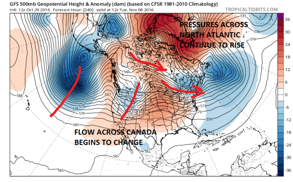
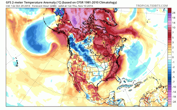
Watch what happens to the temperature anomalies from day 11 to day 16. Below normal temperatures take over a large chunk of the US East of the Rockies.
Now of course as always there is model disagreement on how this all plays out with the European having a bit more of a dynamic approach by day 10. However the more important takeaways here are the strength of higher pressures building across the polar regions (negative A.O. & N.A.O.) and a building ridge in the west which also displaces cold air southward.
The bottom line is that the process of a colder weather pattern setting up for mid November onward is underway even though the specifics of how we get there in the day to day weather at this point remain a mystery. It seems that winter may want to get to an early start across the east and possible before Thanksgiving.
For more on the Arctic and North Atlantic Oscillation this is a great website which explains it all.
MANY THANKS TO TROPICAL TIDBITS FOR THE WONDERFUL USE OF THE MAPS
SNOW REMOVAL COMPANIES FOR YOUR WINTER NEEDS
LONG ISLAND ROCKLAND COUNTY Connecticut

![]()


WINTER 2016-2017 PART 1 OCEAN WATER TEMPERATURES
WINTER 2016-2017 PART 2 ARCTIC SEA ICE AND SIBERIAN SNOW COVER
FiOS1 News Weather Forecast For Long Island
FiOS1 News Weather Forecast For New Jersey
FiOS1 News Weather Forecast For Hudson Valley
NATIONAL WEATHER SERVICE SNOW FORECASTS
LATEST JOESTRADAMUS ON THE LONG RANGE
Weather App

Don’t be without Meteorologist Joe Cioffi’s weather app. It is really a meteorologist app because you get my forecasts and my analysis and not some automated computer generated forecast based on the GFS model. This is why your app forecast changes every 6 hours. It is model driven with no human input at all. It gives you an icon, a temperature and no insight whatsoever.
It is a complete weather app to suit your forecast needs. All the weather information you need is right on your phone. Android or I-phone, use it to keep track of all the latest weather information and forecasts. This weather app is also free of advertising so you don’t have to worry about security issues with your device. An accurate forecast and no worries that your device is being compromised.
Use it in conjunction with my website and my facebook and twitter and you have complete weather coverage of all the latest weather and the long range outlook. The website has been redone and upgraded. Its easy to use and everything is archived so you can see how well Joe does or doesn’t do when it comes to forecasts and outlooks.
Just click on the google play button or the apple store button on the sidebar for my app which is on My Weather Concierge. Download the app for free. Subscribe to my forecasts on an ad free environment for just 99 cents a month.
Get my forecasts in the palm of your hand for less than the cost of a cup of Joe!
![]()