Colder Air Moving East
Colder Air Moving East
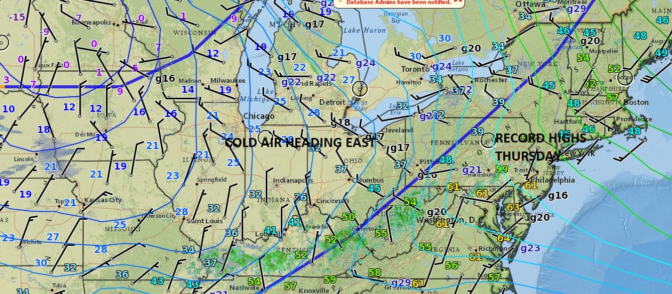
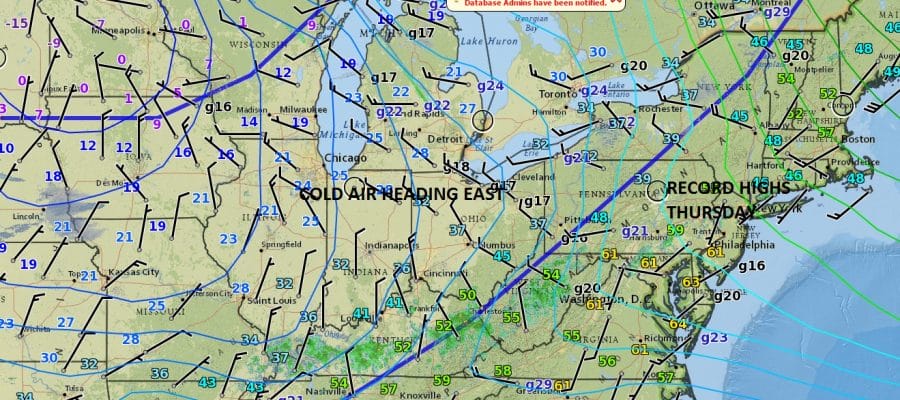
Yesterday’s record highs are but a memory now and we are going to be seeing a colder air mass building in that will take temperatures down close to average over the weekend. The satellite loop shows yesterday’s cold front offshore and now we watch as dry air comes in today. We should see a good amount of sunshine however a northerly wind will keep temperatures in the 40s and those temperatures will ease into the 30s by late afternoon and evening.


The radars will be inactive on Friday and Friday night. The front stalls to the south and a little wave develops on it. However the wave is weak and will only get so far north. The NAM model wants to push an areas of snow through from the afternoon into the early evening. The NAM brings the snow the furthest north of all the models however all the other keep much of the precipitation to the south. I am going to cover for the possibility for a little snow in northern areas and a bit more to the south in New Jersey south of Route 195 and in Southeastern Pennsylvania. At most we are talking about a coating to an inch or so, and in some places to the north barely a coating if anything at all. I’m making no changes in my snow forecast map from 2 days ago.
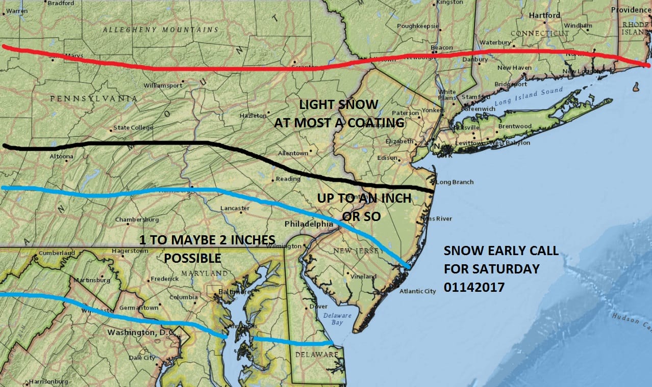
Sometimes these innocent looking systems can surprise in a few pockets here and there and there is always the chance of that happening. However that is a short range forecast problem for Saturday if it is a problem at all.
Sunday will be dry with some sun and clouds and highs in the 30s. The same will hold for Monday. Next week looks like we will be in a thaw pattern so there will be only rain threats later in the week. Longer range prospects to me look like this is going to change again beginning later next weekend. What it evolves into I’m not quite sure, however it seems that the pattern will turn blocky. Where the block sets up will be key to the weather going forward at the end of the month and into February.
For those of you who keep saying that winter is over or that winter hasn’t even arrived let me just point out that your expectations are a bit far fetched. We are having an average albeit volatile winter and we area actually a little bit above normal with snowfall given where we are in the Canada. If you think that the winter is over let me remind you that in 2014-15 the winter never really got started until late in the month of January. In 2013 snowfall was minimal until the “Snowmaggedon” Storm in early February.
SNOW REMOVAL COMPANIES FOR YOUR WINTER NEEDS
LONG ISLAND ROCKLAND COUNTY Connecticut

![]()

ROCKLAND COUNTY TRI STATE SNOW REMOVAL JOHNSTOWN PA


FiOS1 News Weather Forecast For Long Island
FiOS1 News Weather Forecast For New Jersey
FiOS1 News Weather Forecast For Hudson Valley
NATIONAL WEATHER SERVICE SNOW FORECASTS
LATEST JOESTRADAMUS ON THE LONG RANGE
Weather App

Don’t be without Meteorologist Joe Cioffi’s weather app. It is really a meteorologist app because you get my forecasts and my analysis and not some automated computer generated forecast based on the GFS model. This is why your app forecast changes every 6 hours. It is model driven with no human input at all. It gives you an icon, a temperature and no insight whatsoever.
It is a complete weather app to suit your forecast needs. All the weather information you need is right on your phone. Android or I-phone, use it to keep track of all the latest weather information and forecasts. This weather app is also free of advertising so you don’t have to worry about security issues with your device. An accurate forecast and no worries that your device is being compromised.
Use it in conjunction with my website and my facebook and twitter and you have complete weather coverage of all the latest weather and the long range outlook. The website has been redone and upgraded. Its easy to use and everything is archived so you can see how well Joe does or doesn’t do when it comes to forecasts and outlooks.
Just click on the google play button or the apple store button on the sidebar for my app which is on My Weather Concierge. Download the app for free. Subscribe to my forecasts on an ad free environment for just 99 cents a month.
Get my forecasts in the palm of your hand for less than the cost of a cup of Joe!


