Cold Weekend Ahead Chance for Snow/Ice Monday Night Tuesday

Weather in 5/Joe & Joe Weather Show Latest Podcast
Cold Weekend Ahead Chance for Snow/Ice Monday Night Tuesday
We have arrived at the weekend and we have some colder air ahead of us. Today we are going to see a mix of sun and clouds as a cold front approaches. Temperatures will likely top out in the upper 30s and lower 40s and start to ease as the front passes late today and this evening. Some snow showers are possible with the frontal passage and they should be scattered around into this evening. There is an outside chance someone gets the ground whitened up a bit but nothing more.
SATELLITE

The satellite shows clouds to the south as well as clouds to the north as the northwest flow aloft continues to suppress any southern moisture. However the lake effect snow machine is still producing some bands of snow on the regional radar and this will continue into this evening.


Cold high pressure will build in tonight and for the weekend leading us down to the upper teens and lower 20s Saturday morning. Saturday will be a cold day with ineffective sunshine, a gusty wind with most highs just in the upper 20s and lower 30s and the wind will make it feel even colder.

Sunday we will sunshine and it will still be a bit breezy early in the day before the winds drop off. HIghs will be mostly in the 30s . Then attention turns to early next week as the first in a series of storm systems heads our way from the Southern Plains.
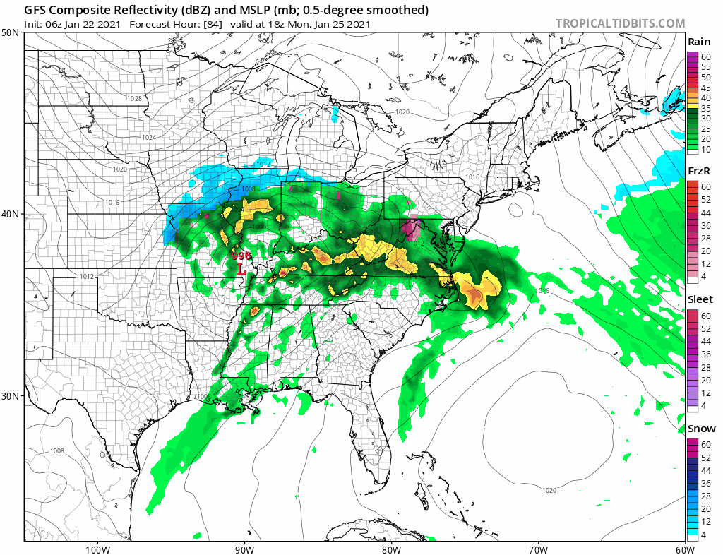
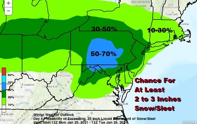
We are starting to see models come in a little more organized with the upper feature that is supporting this low. The primary moves into Southeast Ohio/Northern West Virginia. The isobars are pointed east so a secondary forms east of the Southern Delmarva peninsula and we see an area of snow to the north of this track.
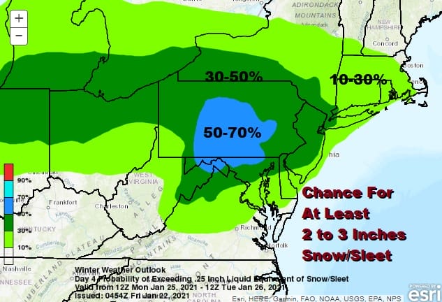
My thinking that this looks like a 2 to 4 inch type scenario. Perhaps there is a 3-6 inch max area somewhere in the zone indicated by the Weather Prediction Center folks where they are showing a large area of up to 50% potential for at least 2 to 3. Snow overspreads the area from west to east late Monday afternoon or evening and then lasts into Tuesday morning before ending from west to east. This should NOT become as some are referring to it as “a big one” because this is not strengthening as it moves eastward. The block to the east is suppressing development What we need to look at regarding the possibility of some upside is if we see a robust area of overrunning precipitation on the radars next week and how well they hold together given the limited support. Overnight models generated 1/2 to 3/4 of an inch of liquid for most so if every flake sticks with those amounts you are talking 5 to 7 inches for someone. This is all at this point simply talking out loud speculation which is perfectly reasonable at this stage. There are a few more systems in the pipeline for later next week and beyond but as you know I’m a one storm at a time type of weather guy!
BE SURE TO DOWNLOAD THE FREE METEOROLOGIST JOE CIOFFI WEATHER APP &
ANGRY BEN’S FREE WEATHER APP “THE ANGRY WEATHERMAN!
MANY THANKS TO TROPICAL TIDBITS FOR THE USE OF MAPS
Please note that with regards to any severe weather, tropical storms, or hurricanes, should a storm be threatening, please consult your local National Weather Service office or your local government officials about what action you should be taking to protect life and property.


