
COLD NIGHT AHEAD TEMPERATURES IN THE 20S TO LOWER 30S
SUNNY SUNDAY WITH LESS WIND
DRY MONDAY BUT RAIN ARRIVES MONDAY NIGHT INTO TUESDAY
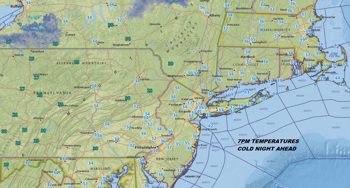
It was a cold windy day and parts of Northern New Jersey & the Hudson Valley saw their first snow flurries of the season. You can thank a very active lake effect snow machine today and an upper trough that moved through. Now we look ahead to a cold night with less wind and clear skies. Temperatures at 7pm were all in the 30s so by morning lows will be in the mid 20s to lower 30s. Even the warmer urban centers should see their first freezing temperatures of the season. Skies are mostly clear on the satellite loop as clouds to the northwest thin out as the we go through the night.
EASTERN SATELLITE

REGIONAL RADAR

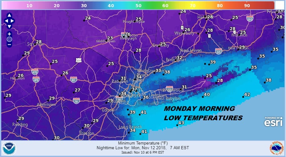
Sunday will be nice and sunny with less wind and highs should be in the middle to upper 40s. Sunday night into Monday morning will be clear with light winds. That will mean some radiational cooling Sunday night, Monday morning lows in the cold spots will be down in the 20s in many areas.
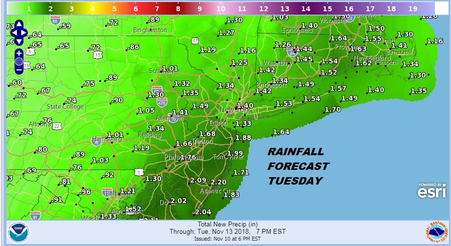
Monday will be dry during the day with sunshine giving way to increasing afternoon clouds. Low pressure from the Gulf States heads up the East Coast so get ready for another soaking rain moving in during Monday night. The system is another fast mover so rains will be tapering off from south to north Tuesday morning. This system will be loaded with moisture so this looks to be another 1 to 2 inch rain producer.
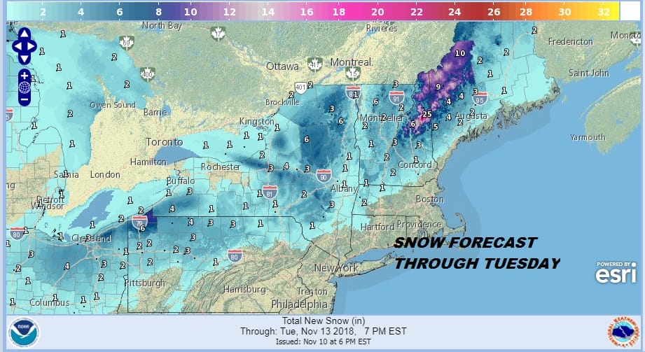
As far as snow is concerned it is not an issue for us or anywhere close to the coast. Areas from the Catskills northward and northeastward could pick up more snow though it will tend to be elevation driven again.
Another shot of cold air comes in behind this system so look for another ride down in temperatures Tuesday night into Wednesday morning with lows in the 20s to lower 30s. Dry weather should be with us Wednesday and Thursday before another storm threatens us with rain at the end of the week.
JOESTRADAMUS looks at the long range weather pattern for the next 2 weeks in his latest post.
SUBSCRIBE TO PATREON FOR A WEATHER EXPERIENCE FREE OF ADS, EXCLUSIVE VIDEOS FOR MEMBERS ONLY AND MUCH MORE…STARTS AT $2 A MONTH..MESSAGE ME AT ANY TIME

MANY THANKS TO TROPICAL TIDBITS FOR THE USE OF MAPS
Please note that with regards to any tropical storms or hurricanes, should a storm be threatening, please consult your local National Weather Service office or your local government officials about what action you should be taking to protect life and property.
LATEST JOESTRADAMUS ON THE LONG RANGE

