Cold Night Ahead Dry Days Continue No Storms Through The Weekend

Weather in 5/Joe & Joe Weather Show Latest Podcast
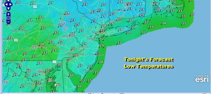
Cold Night Ahead Dry Days Continue No Storms Through The Weekend
Sunday’s storm system continues to churn to our east and it strengthened today. That brought a cold northwest wind that was busy for much of the day. Temperatures held in the 30s to near 40 with the wind making it feel about 10 degrees colder. The night ahead will be cold under at least partially clear skies. Lows will be in the 20s to around 30 by Thursday morning.

The storm center off shore is still in range on the visible satellite picture. Cloud bands are still around and the regional radar is showing some bands of precipitation backing westward toward Cape Cod but none of this reaches here as it will remain dry right through the weekend.
SATELLITE


Not much will be happening over the next 4 days with little change from day to day as far as temperatures go. The strong block is keeping us chilly and dry but not overly cold. The wind should still be somewhat busy Thursday as the low to the east starts to pull further away. However the gradient still remains into the weekend so breezes will continue. Winds will turn more north and then northeast over time. Look for at least some sunshine each of the next 4 days. Daytime highs will be generally in the 30s to near 40 and nighttime lows will be in the 20s to near 30.

The strong block is forcing storms to track to the south and the first of these storms will move through the Gulf States Thursday into Friday and then exit the Carolinas to the northeast Friday night and Saturday. Snow will fall across parts of the deep south and then in the Western Carolinas to Southern Virginia Friday into early Saturday. Winter Storm Watches are posted for the Western Carolinas and more watches could go up on Thursday. However as the NAM and other models show, the low exits and nothing more than high clouds make it up here for Friday into Saturday morning.

The blocking pattern continues for all of next week and this will create more forecast headaches. Another system will be moving across the South and will try to make the turn northward up the coast later Tuesday Wednesday but that will depend on the strength of the block. Too strong and the low will follow a similar track as the one for Friday into Saturday. More changes are afoot later next week as a stronger trough drops into the Eastern US. Unusually high uncertainty in the outlook continues until further notice.
BE SURE TO DOWNLOAD THE FREE METEOROLOGIST JOE CIOFFI WEATHER APP &
ANGRY BEN’S FREE WEATHER APP “THE ANGRY WEATHERMAN!
MANY THANKS TO TROPICAL TIDBITS FOR THE USE OF MAPS
Please note that with regards to any severe weather, tropical storms, or hurricanes, should a storm be threatening, please consult your local National Weather Service office or your local government officials about what action you should be taking to protect life and property.


