Cold Front Arrives Friday, Low Pressure Heads Our Way For The Weekend
When you look at the last month or so the weather has been rather busy over us either with major storms and severe weather to 3 days of record cold for much of the Eastern US. This past weekend we dealt with a rather large disorganized systems that kept things raw and damp for the last couple of days. We even had some ocean effect snow over Long Island and New Jersey this past Sunday. We seem now to be settling into a bit more of normalcy for the next 2 days though improving weather conditions have been somewhat slow to occur. Clouds are still around this evening as we sit inside the bowl of a broad upper trough. A new low is going to develop well offshore of the MIddle Atlantic coast tonight. This should help to clear things out on Wednesday and winds finally pick up from the northwest and dry air returns.
SATELLITE

REGIONAL RADAR

We are still seeing lots of broken clouds on the satellite pictures this evening. Radars locally are quiet. There are a few light showers in Southeast Virginia and Northeast North Carolina. This is all part of the new low that forms offshore and clears it out later tonight.
LOCAL RADAR NEW YORK CITY

LOCAL RADAR PHILADELPHIA


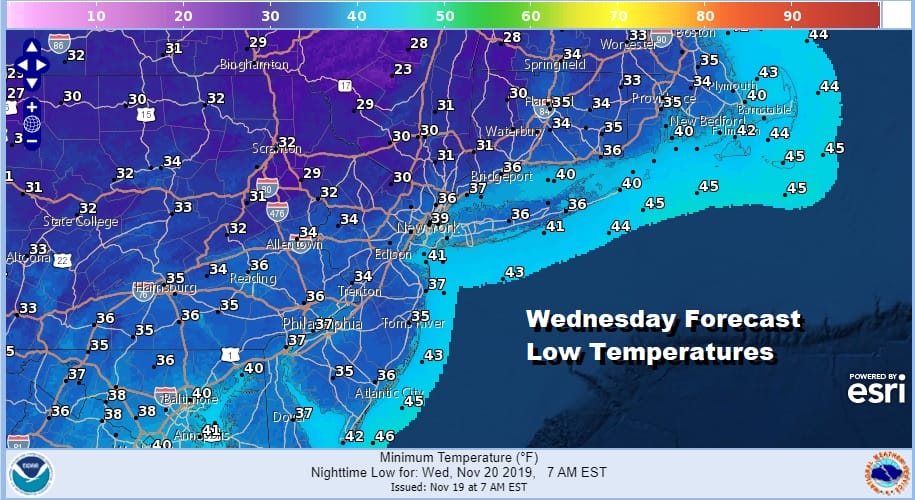
Cloud cover is going to help hold temperatures up a bit overnight. Most lows inland will be in the 20s to lower 30s especially where skies can clear but coastal and warmer urban areas will bottom in the mid to upper 30s by morning.
Wednesday should see some sunshine though some clouds still could linger along the coast. Highs will reach the upper 40s and lower 50s. Thursday I think is the best day of this week with sunshine for a good portion of the day. Highs will reach the low and middle 50s.
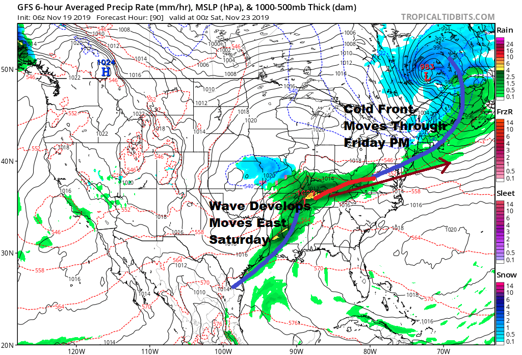
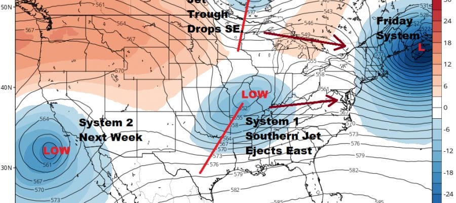
There are no major changes to what we see for Friday with the cold front coming along with a few showers. The front stalls out and then energy now moving into the Southwest US will be ejected eastward. This times out with another system coming down in the northern have of the jet stream.
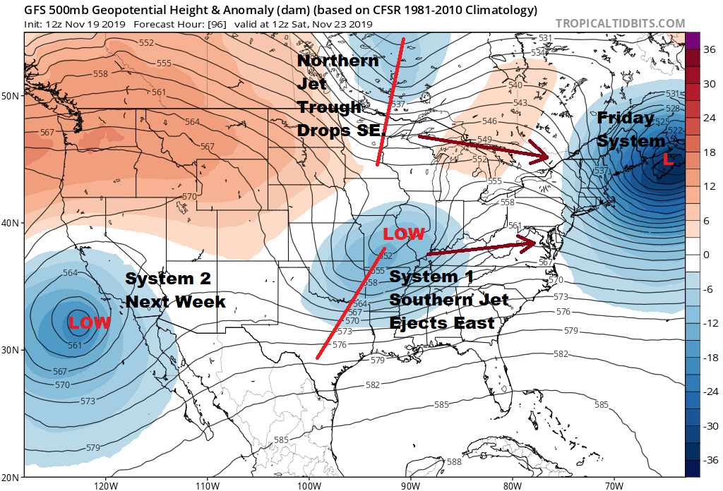
We have a split low in the atmosphere across the US which means we have two separate jet streams. It is hard enough when you are dealing with energy from 1 jet stream flow but when you have two it is even more problematic because timing becomes more difficult. Also you have to figure out whether the two streams eventually phase together or not. Then there is the issue of the energy itself in the southern jet. Does it all come out as one major piece or does it come out as minor pieces with less impact? Models seem to be going the route of 1 larger piece coming out mainly do to new energy replacing it in the southwest. It simply kicks the lead system out. The map above breaks down the pieces that are in play for the weekend forecast.
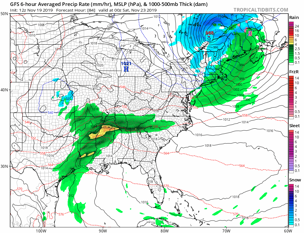
Weather models show a rather robust low developing just offshore on Sunday as low pressure moves across the Tennessee Valley and heads toward the Maryland/Delaware coast. Only marginal cold air is available here but you might see rain change over to snow in areas across interior Southern & Central New England from this while it may be mostly rain elsewhere. It is very early in the game here of course. The time frame here is late Saturday into Sunday.
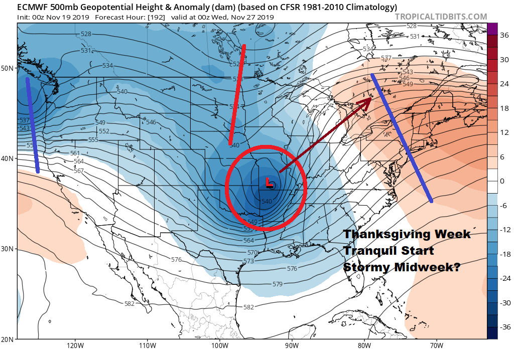
Next week is Thanksgiving week and it will be all about system number two. This looks even more vigorous than our weekend low. With that first trough pulling out an upper ridge builds along the East Coast early next week. At least that means that Monday and Tuesday should be fine weather wise. Then with this rather dynamic looking upper air some sort of major storm could develop for the Plains and Western Lakes for Wednesday. It will mean a cold front Wednesday for the East Coast bringing warmer temperatures and a chance for showers. This would be followed by dry and seasonal conditions behind it for Thanksgiving day and for Friday which is of course the kick off to the holiday shopping season.
BE SURE TO DOWNLOAD THE FREE METEOROLOGIST JOE CIOFFI WEATHER APP &
ANGRY BEN’S FREE WEATHER APP “THE ANGRY WEATHERMAN!
MANY THANKS TO TROPICAL TIDBITS FOR THE USE OF MAPS
Please note that with regards to any severe weather, tropical storms, or hurricanes, should a storm be threatening, please consult your local National Weather Service office or your local government officials about what action you should be taking to protect life and property.


