Cold Dry Into Thursday Before Next Storm Heads Our Way With Snow Ice To Rain
Overnight we had cold air drain southward from high pressure to the north and a storm to the east, south of Nova Scotia. Throw in some snow cover inland and we have temperatures that bottomed in the 20s clear down to Virginia and in the teens and single digits in the other direction in upstate NY and New England. This means that inspite of a good deal of sunshine, temperatures in many areas today will be at best in the 30s to around 40 degrees for highs. It might be a little higher, lower 40s from South Jersey south and west. Overall it is a chilly but nice December day. Another cold night lies ahead
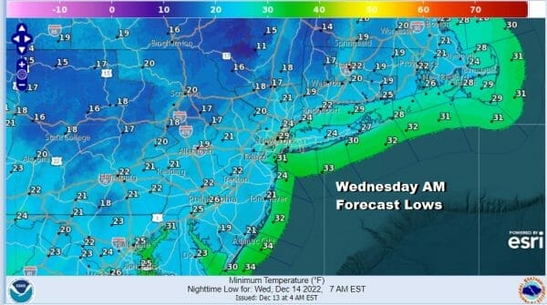
Tonight will be another night of clear skies and very cold conditions with most lows along the coast and warmer urban areas in low to mid 30s but inland lows will be in the teens especially where there is snow cover. As far as radars are concerned there are no issues here until Thursday when the next storm system approaches.
SATELLITE

WEATHER RADAR

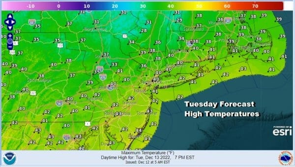
Wednesday will be another day of sunshine and cold temperatures with most highs in the 30s to around 40 degrees with perhaps low 40s in warm spots from South Jersey south and west. Wednesday night into Thursday morning will be important to the forecast for Thursday as another cold night could keep things cold enough when precipitation arrives during Thursday.

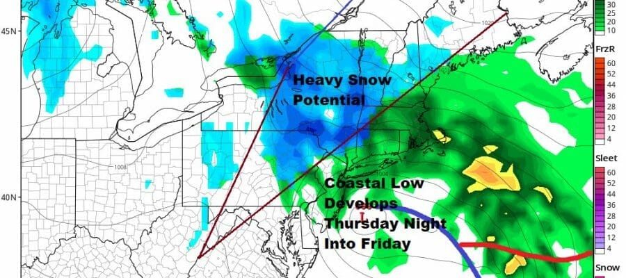
This system will be coming in slightly different than what we might be used to thanks to the block. A major storm in the Plains moves east but lingers around the Great Lakes while a secondary low develops near Chesapeake Bay and heads northeast to off the New Jersey coast Friday. The high to the north is wedged in between it and the storm to east in the Atlantic that drops southeast from Nova Scotia. This will lead to questions as to cold air being wedged inland leading to precipitation to start as snow or sleet even at the coast. The primary low in the Great Lakes is just too strong to make it all snow for all or most of the area from Eastern Pennsylvania. However from Eastern Pennsylvania to Northwest New Jersey to the Hudson Valley west of Route 87 could see sizeable snow amounts.

The red lines indicate the area where is the potential for heavy snow of 4 to 6 inches or more. The GFS has a slightly colder solution than the other models where the southern edge of the heavy snow line is further south and closer to the coast but right now I’m more comfortable leaving that line further inland. Once this storm is done we should see improving weather conditions with colder dry air over the weekend.
BE SURE TO DOWNLOAD THE FREE METEOROLOGIST JOE CIOFFI WEATHER APP &
ANGRY BEN’S FREE WEATHER APP “THE ANGRY WEATHERMAN!
MANY THANKS TO TROPICAL TIDBITS & F5 WEATHER FOR THE USE OF MAPS
Please note that with regards to any severe weather, tropical storms, or hurricanes, should a storm be threatening, please consult your local National Weather Service office or your local government officials about what action you should be taking to protect life and property.


