DOWNLOAD MY NEW FREE JOESTRADAMUS WEATHER APP FOR ALL DEVICES
THE APP IS ABSOLUTELY FREE TO ALL BUT CONSIDERING SUBSCRIBING TO PATREON FOR A WEATHER EXPERIENCE FREE OF ADS, EXCLUSIVE VIDEOS FOR MEMBERS ONLY AND MUCH MORE…STARTS AT $2 A MONTH..MESSAGE ME AT ANY TIME
Coastal Storm Revving Up But Heading Out 60s Wednesday Sunshine
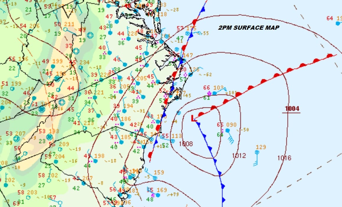
The satellite loop this evening shows the strengthening storm along the North Carolina Coast. Heavy rains have been moving through the Carolinas and there was even some snow in parts of Western North Carolina this afternoon. Now we watch as the low begins to move to the east northeast offshore before it turns to the northeast. That easterly component of motion guarantees that most of the area will see only a grazing pass overnight. We have been thinking that the western edge of the rain will run back to about NYC and in New Jersey mainly east of the Garden State Parkway and we see no reason to alter that view.
SATELLITE

REGIONAL RADAR

Regional radar shows the heavy rain over Southeast Virginia and North Carolina with the lead echos starting to show up on the local radar views. We won’t see anything of consequence for this evening but rains will start up in coastal areas between 8pm and 11pm and they should end from west to east from 5am to 8am on Wednesday. West of the Garden State Parkway little or nothing will fall while to the east amounts will range from about a tenth of an inch in NYC to a quarter to a half inch over Long Island and Coastal Connecticut with as much as an inch in Eastern Long Island and Eastern Connecticut.
LOCAL RADAR NEW YORK CITY

LOCAL RADAR PHILADELPHIA


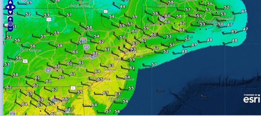
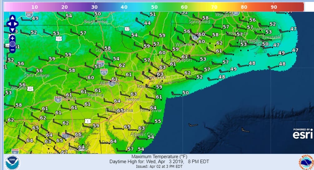
This storm does intensify as it moves offshore and that should mean rapid clearing behind it on Wednesday. We should see sunshine develop Wednesday morning from west to east and a partly to mostly sunny afternoon. The air behind this is not all that cold so the strong April sun should send temperatures into the 60s with a nice active breeze from the northwest.
There are no changes in the weather outlook for the rest of the week. Thursday look for sunshine and arriving clouds with highs in the upper 40s to lower 50s. An onshore flow sets up for Friday which will put us in clouds and a cold rain with a raw ocean wind. Highs will just be in the 40s. If everything goes according to plan we will see leftover clouds and some developing sunshine for Saturday and some sun to start Sunday before clouds arrive. Highs both days will be in the 60s.
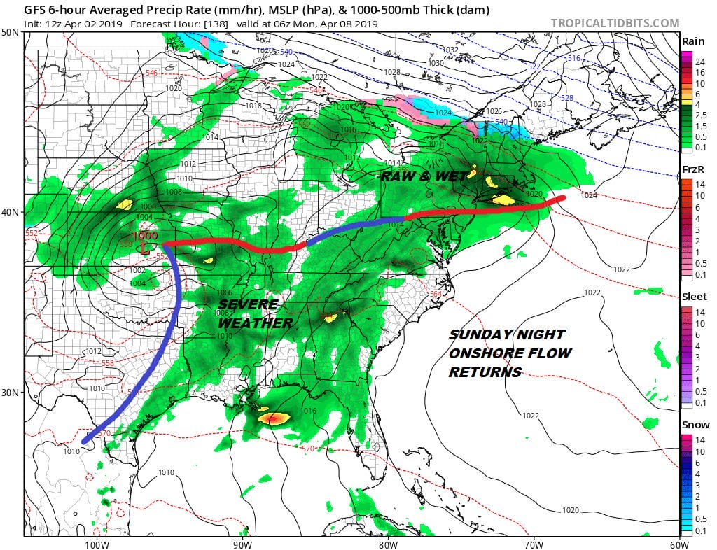
I was thinking that we could hold on to warmer temperatures through Monday but the weather models have different ideas on how the weather evolves over the weekend. The GFS wants to set up an onshore flow Sunday night and Monday with rain coming back while the European wants to take a low from the Plains to the Great Lakes on Monday with models developing blocking over Greenland. Actually both models show the blocking developing but handle it differently. Blocking in the spring is normal and it can lead to long stretches of dreary weather here especially along coastal areas. We will examine this later on a long range JOESTRADAMUS post.
MANY THANKS TO TROPICAL TIDBITS FOR THE USE OF MAPS
Please note that with regards to any tropical storms or hurricanes, should a storm be threatening, please consult your local National Weather Service office or your local government officials about what action you should be taking to protect life and property.


