Coastal Low Brings Clouds & Light Rain Immediate Coast
But Some Sunshine Well Inland
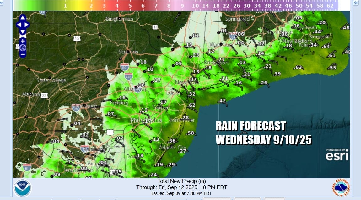
This is going to be one of those weather days where location means everything. If you are along the coast you will be dealing with cloud cover for much of the day and there is the chance that there might be some light rain along the immediate coast for a short period of time. Under overcast skies highs today will not get out of the 60s and this will come with a somewhat raw northeast wind. However inland areas in Pennsylvania and Upstate New York and Connecticut north of Route 84 you might see skies go partly sunny at times with highs in the 70s.
Where it does rain (or if it does) amounts will be light. I frankly think that much of what we see here is overdone including some of the half inch amounts we see for parts of Coastal New Jersey for example. Inland areas from Western New Jersey westward probably won’t see any rain as well as the Hudson Valley north of Route 84. Even the coast won’t get much out of this.
SATELLITE WITH LIGHTNING STRIKES
WEATHER RADAR
The coastal low moves away to the northeast tonight and it is gradually going to be replaced by a new high pressure cell building southeast into Southeast and Atlantic Canada over the next several days. This leaves us cut off from any kind of moisture flow either from the Atlantic or the Gulf of Mexico. Weather models show no rain until possibly Sunday when a front and upper trough drop southward through the Northeast and Northern Mid Atlantic states.
Tonight drier air comes in on a north wind and skies will clear from northwest to southeast. Overnight lows will be in the 50s except near 60 for warmer urban areas. Thursday lots of dry air on north to northeast winds means a mostly sunny day. High temperatures will be warming to the upper 70s to near 80 degrees though it will be a little cooler along south and east facing shorelines.
We will cool off nicely Thursday night with inland lows in the mid to upper 40s. Coastal areas and warmer urban locations will bottom mostly in the mid to upper 50s. Friday will be a little cooler than Thursday but it will be a mostly sunny day. Most highs will average in the middle 70s with slightly lower temperatures again along south and east facing shorelines.
The weekend right now is setting up to be dry Saturday with partly to mostly sunny skies and highs in the mid to upper 70s. As mentioned earlier we have a weather front that will be moving southeastward from Eastern Canada into New England Sunday and this will bring the possibility of showers. Sunday highs will be in the 70s. Then it is back to dry weather and seasonal temperatures for the start of next week.
BE SURE TO DOWNLOAD THE FREE METEOROLOGIST JOE CIOFFI WEATHER APP \\\&
ANGRY BEN’S FREE WEATHER APP “THE ANGRY WEATHERMAN!
MANY THANKS TO TROPICAL TIDBITS FOR THE USE OF MAPS
Please note that with regards to any severe weather, tropical storms, or hurricanes, should a storm be threatening, please consult your local National Weather Service office or your local government officials about what action you should be taking to protect life and property.