
Cloudy Raw Wednesday Stronger Low Friday Night Brings Rain Snow &
Unusual Cold Mothers Day Weekend
We are looking at a lot of clouds today along with an inshore flow so those two factors are going to hold temperatures down. We also have coastal flood advisories up for areas from Long Island and Southern New England south to Delaware thanks to the full moon and the easterly flow. There will be one high tide cycle tonight that will be problematic and minor coastal flooding is expected. This should be manageable.
SATELLITE

REGIONAL RADAR

The satellite picture shows lots of clouds across the Mid Atlantic to Southern New England. Skies are clear to the northeast in Eastern New England thanks to weak higher pressures there which set up the east flow. As to the activity on the radar, it is broken piecemeal over parts of Pennsylvania as well as offshore with a gaping hole of no activity in between at least for now. What is around is mainly on the light side. This is not going to be a an all day rain maker and any rain will be light, patchy, and of the on and off variety.
LOCAL RADAR NEW YORK CITY

LOCAL RADAR PHILADELPHIA


We will play through this today as low pressure offshore starts to move northeastward. Most of the rain will pull away tonight and skies should partially clear toward morning. Temperatures today will struggle mainly in the low to mid 50s in most places. Ocean exposed areas will probably not get much out of the upper 40s. Most lows tonight will be in the upper 30s to mid 40s.

Thursday should be a better day with some sunshine returning. That will be enough to send temperatures up into the 60s in most places which is still going to be a bit below average. Then we look ahead to Friday a slow pressure comes out of the Southern Plains and heads northeastward as an unusually cold air mass drops southward out of Canada. This is going to produce an unusually late snowfall for areas well inland and with elevation from the Poconos to the Catskills to the Berkshires. The NAM model takes an overly aggressive view of this. Timing wise this all falls at night (Friday night into Saturday morning) so if it is going to snow and stick this time of year it has to come at night. For most areas it will be a cold rain that develops late Friday afternoon lasting into early Saturday morning.
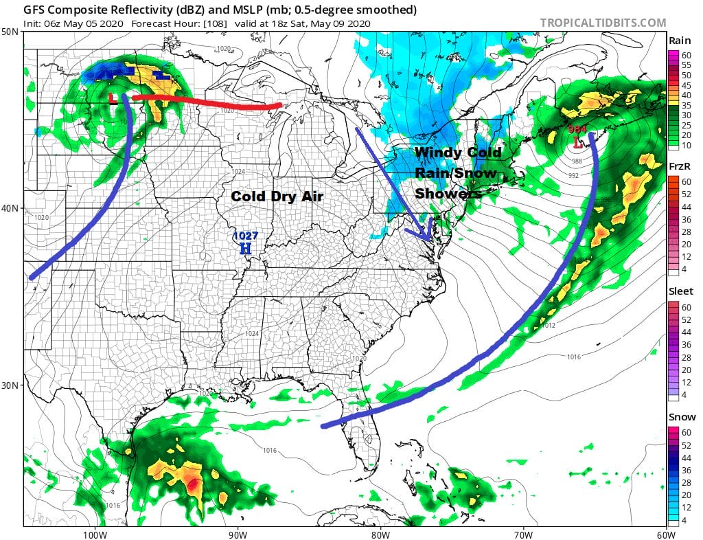
Get set for a cold Mothers Day weekend. The low heads to Northeastern New England Saturday and strengthens. The pressure gradient tightens up considerably and that means strong gusty winds, self destructive sunshine, rain and even some snow showers will be running around Saturday as the cold upper trough moves over head. Temperatures Saturday are going to be ridiculously cold for this time of year. Highs will be in the upper 40s to at best lower 50s.

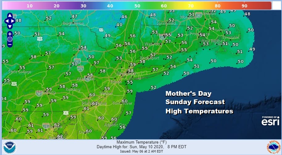
Now let us add to that the likelihood of gusty winds of 30 to 40 mph or higher and it will feel like it is down in the 30s! The other issue remains whether there will be a late season freeze Sunday morning with lows dropping to the upper 20s to mid 30s in most areas. Winds will still be gusty into Sunday Mothers Day so that could help keep temperatures up a bit. Either way it will be cold. Sunday looks like a nice sunny breezy day with highs at least getting back into the 50s everywhere.
Next week sees some subtle changes developing as the week wears on. Another low heads southeast from the Great Lakes and offshore Monday night into early Tuesday with some rain possible. Then we see the pattern normalizing somewhat with perhaps something more like mid May than mid March developing later next week. We will visit those prospects and look closer at snow chances later today.
BE SURE TO DOWNLOAD THE FREE METEOROLOGIST JOE CIOFFI WEATHER APP &
ANGRY BEN’S FREE WEATHER APP “THE ANGRY WEATHERMAN!
MANY THANKS TO TROPICAL TIDBITS FOR THE USE OF MAPS
Please note that with regards to any severe weather, tropical storms, or hurricanes, should a storm be threatening, please consult your local National Weather Service office or your local government officials about what action you should be taking to protect life and property.


