ANOTHER DAY WITH #BADHAIRWEATHER
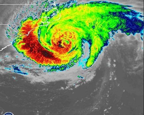
HURRICANE FLORENCE CATEGORY 2 NEARING CAROLINA COAST
LOCAL RADAR PHILADELPHIA


We continues to sit under a decaying cold front that has all but disappeared. We are sitting again with lots of clouds overhead with very humid conditions and temperatures that will be mostly in the 70s today. Humidity levels remain exceptionally high yet again and there is the chance for passing downpours though there should be few downpours around today verses yesterday. To the south on the satellite loop we can see Hurricane Florence as it nears the North Carolina coast. The structure of the hurricane has deteriorated overnight thanks to southerly shear that developed over the hurricane yesterday. Once again it bears repeating that Florence is absolutely no threat here with no impact to our area whatsoever from the landfalling hurricane.
EASTERN SATELLITE

REGIONAL RADAR

We are seeing a few scattered showers on the radar this morning. This is another day where the downpours are likely to pop up later in the day. Breaks of sun will be self destructive as they will cause more clouds to develop overhead.
LOCAL RADAR NEW YORK CITY

LOCAL RADAR PHILADELPHIA

Friday we will start out with lots of clouds but as high pressure begins to build down from New England we could see sky conditions improve as the day wears on and some areas could see some sunshine developing Friday afternoon. Highs will be in the upper 70s to around or just over 80. The weekend looks good with some sunshine both Saturday and Sunday. It will be on the humid side with highs in the upper 70s to lower 80s. All this happens while Florence continues to rake the Carolinas with flooding rains and wind.
HURRICANE FLORENCE NEARS THE OUTER BANKS
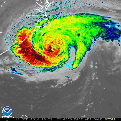
Latest satellite loops show that the core of Hurricane Florence has taken a bit of a hit from southerly shear yesterday and is no where near as well defined as it was a few days ago. Still the hurricane is a category 2 with 110 mph winds and a large area of gales. This creates a large storm surge impact along the Carolina coast as the storm approaches land. The forecast track logic remains the same. We will see an initial approach to near Wilmington North Carolina and then a turn west or southwestward with a landfall near the North Carolina/South Carolina border. The European is a bit further south with a final landfall near or just southwest of Myrtle Beach late Saturday afternoon.
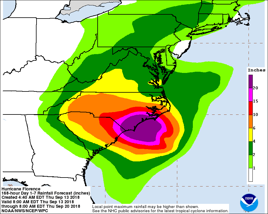
Such a long duration event means that rains will be excessive and 20 inch plus amounts are likely over a large area. To the north in Virginia the rain shown will not occur until after Florence makes its final landfall and begins a turn northward up along or just east of the Appalachians. It would appear that we will be experience the rains from Florence on Tuesday as the remnant low heads our way though how this plays out is in question. We will address this later today.
MANY THANKS TO TROPICAL TIDBITS FOR THE USE OF MAPS
Please note that with regards to any tropical storms or hurricanes, should a storm be threatening, please consult your local National Weather Service office or your local government officials about what action you should be taking to protect life and property.
LATEST JOESTRADAMUS ON THE LONG RANGE


