
Chilly June Night Ahead

Chilly June Night Ahead
Dry For Belmont Stakes
Weekend Looks Mostly Dry

The strong vortex in Easten Canada totally dominates the pattern across the Eastern United States. Cool dry air is all the way south into Northern Florida and there is no sign of this overall pattern breaking down into early next week. At least we are done with the series of upper air disturbances moving through. Severe weather from today’s system was extensive across New Jersey especially Central and South Jersey where a waterspout was observed over Barnegat Bay.
Chilly June Night Ahead
Radar Loops


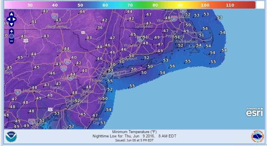
Radars are done now as showers are gone and the sun is coming out for the last hour before sunset. Tonight’s lows will be quite chilly across the entire region with an extensive area of 40s just inland from the coast and urban areas.
Chilly June Night Ahead Forecast Low Temperatures Thursday Morning
The next 2 days look good with lots of sunshine and highs in the low to mid 70s on Thursday and middle to some upper 70s on Friday.
The weekend to me looks okay overall. There will be a front coming through Saturday night but latest model runs continuing the trend of being drier and drier. There might be a shower or thunderstorm Saturday night. The daytime Saturday for the Belmont Stakes looks good with a mix of sun and clouds. Highs will be in the 70s to near 80. Sunday I’m also looking for a mix of sun and clouds with highs in the upper 70s to lower 80s. There might be a passing shower or thunderstorm on Sunday but it looks to be isolated in nature. Here is a more detailed forecast and odds for the Belmont Stakes.
JOESTRADAMUS HURRICANE SEASON GUEST FORECAST
FiOS1 News Weather Forecast For Long Island
FiOS1 News Weather Forecast For New Jersey
FiOS1 News Weather Forecast For Hudson Valley
NATIONAL WEATHER SERVICE SNOW FORECASTS
LATEST JOESTRADAMUS ON THE LONG RANGE
Weather App

Don’t be without Meteorologist Joe Cioffi’s weather app. It is really a meteorologist app because you get my forecasts and my analysis and not some automated computer generated forecast based on the GFS model. This is why your app forecast changes every 6 hours. It is model driven with no human input at all. It gives you an icon, a temperature and no insight whatsoever.
It is a complete weather app to suit your forecast needs. All the weather information you need is right on your phone. Android or I-phone, use it to keep track of all the latest weather information and forecasts. This weather app is also free of advertising so you don’t have to worry about security issues with your device. An accurate forecast and no worries that your device is being compromised.
Use it in conjunction with my website and my facebook and twitter and you have complete weather coverage of all the latest weather and the long range outlook. The website has been redone and upgraded. Its easy to use and everything is archived so you can see how well Joe does or doesn’t do when it comes to forecasts and outlooks.
Just click on the google play button or the apple store button on the sidebar for my app which is on My Weather Concierge. Download the app for free. Subscribe to my forecasts on an ad free environment for just 99 cents a month.
Get my forecasts in the palm of your hand for less than the cost of a cup of Joe!
![]()
![]()

MENTION JOE CIOFFI AND GET A 5% DISCOUNT


