Caribbean System Better Defined Late Today, Tropical Cyclone Development Likely This Weekend
Caribbean System Better Defined Late Today,
Tropical Cyclone Development Likely This Weekend
Satellite loops this afternoon show that the disturbed weather in the Northwest Caribbean has become better defined. Thunderstorms have been increasing all day long. A broad low pressure center is located just east of the East Coast of the Yucatan. This is probably preventing any kind of meaningful development as well as hostile conditions aloft however all models suggest that the low will find its way into the Gulf of Mexico Friday night and Saturday where conditions will be conducive for development. The National Hurricane Center raises the chances for development now to 70 percent over the next 5 days.
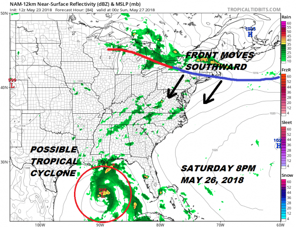
Weather models all seem to be zeroing in on a developing low in the South Central Gulf of Mexico during Saturday. The NAM is showing what could be a strong tropical depression or tropical storm drifting slowly northward Saturday evening.
NAM MODEL FORECAST 8PM SATURDAY MAY 26, 2018
We will be dealing with a weather front moving southward from upstate NY & New England which complicates the weather picture for Sunday and Monday of the holiday weekend. This tropical system is likely to bring heavy rains across NW Florida & the Eastern & Central Gulf States beginning Saturday night and lasting well into next week. We will have more on this tonight on the JOE & JOE show on Facebook at 9:!5pm Eastern Time.
LATEST JOESTRADAMUS VIDEO
NATIONAL HURRICANE CENTER LATEST DISCUSSION 8PM WEDNESDAY 5/23/2018
A broad surface low centered over the southeastern Yucatan
Peninsula has become better defined since yesterday, and it
continues to produce a large area of cloudiness and showers
extending from the northwestern Caribbean Sea across Cuba into the
Florida Straits.  Continued slow development of this system is
possible during the next couple of days as it drifts northward near
the Yucatan Peninsula.  Thereafter, environmental conditions are
forecast to become more conducive for development, and a subtropical
or tropical depression is likely to form this weekend over the
eastern or central Gulf of Mexico.  Regardless of development,
locally heavy rainfall is possible across western Cuba and the
Cayman Islands during the next few days, and over much of Florida
and the northern Gulf Coast during the weekend. For more information
on the heavy rain threat, please see products issued by your local
weather office. The next Special Tropical Weather Outlook on this
system will be issued by 800 AM EDT on Thursday.
* Formation chance through 48 hours...low...10 percent.
* Formation chance through 5 days...high...70 percent.
FiOS1 News Weather Forecast For Long Island
FiOS1 News Weather Forecast For New Jersey
FiOS1 News Weather Forecast For Hudson Valley


