
Canadian Weather Model Gfs Model
![]()
Canadian Weather Model Gfs Model overnight runs are beginning to line up a little bit closer to each other but there were some subtle shifts in both models which would seem to lessen any serious threat for snow at the end of this week. This does not mean that there can’t be more shifts in the next few days, however right now the outcome appears to be a modest snow threat for coastal areas.
Canadian Weather Model Gfs Model Surface Maps Friday Evening

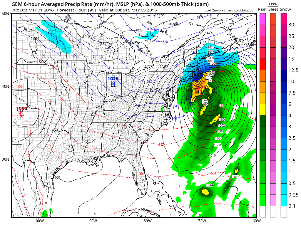
These are the two model surface maps side by side for Friday evening. The Canadian weather model has a much deeper (more intense) low than the GFS with the GFS further south. The issue regarding this remains the same. The upper air is not lining up in a way that favors a coastal snowstorm for the northeast.
Canadian Weather Model Gfs Model Upper Air Maps Friday Evening

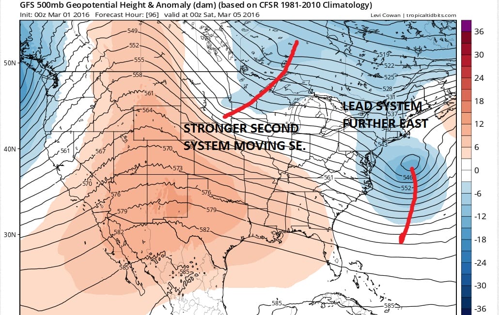
The upper air maps show the important differences in the 2 models. The Canadian has a much more active northern jet in the east. It attempts (but does not succeed) in trying to phase the two. The outcome is a deeper southern stream energy stream that lifts further north and left of the GFS model. The reason for this is that the Canadian does not show the second short wave system behind it. The GFS sees this (and so does the Euro model for the last several runs). That second system is flattening the flow just enough to prevent this from lifting up closer to the coast. The Canadian weather model sees enough of that system to at least shift the intense low further to the east. The result on the Canadian weather model is a glancing blow to the coast, while hitting Cape Cod and Southeast New England much harder. The GFS has the northern edge of snow to the coast and not much more. Even Southeast New England misses out of the core of the storm.
Now given all this there are still lots of questions and some uncertainty. Suppose that second system is weaker in reality? Is their time for the northern stream to line up a little differently to allow this system to lift closer to the coast? Time is becoming a more serious player here as models begin to zero closer to a final outcome. There is certainly still time for models to shift around a bit more. However it seems to me that in order for this to be a true player, that second short wave needs to be much weaker than forecast by both models. This is the only way there would be more room.
One other important note. We have seen the last minute westward shift before. Given that it has happened several times with consequences for the coast, I would not rule it out. The Euro model run to night may hold a key answer to all this when it runs. And do not rule out the possibility of another period of snow here Saturday night into Sunday morning as the second system moves through, though that looks to be weak in nature regardless.
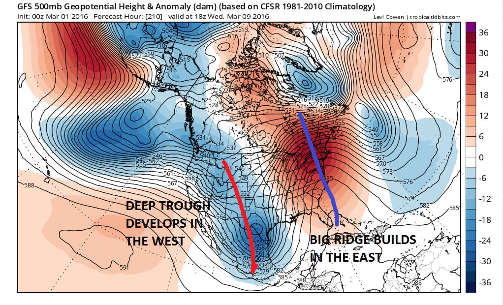
Longer term this may be the last gasp as the long range pattern looks to turn very warm in the east starting later next week and beyond. All models build a big ridge in the east and a deep trough in the west. This would certainly lead to temperatures at the very least in the 60s at some point and possibly higher as we move to later next week. This could be the last reasonable chance for snow lovers before the pattern flips.
Canadian Weather Model Gfs Model UPPER AIR FORECAST LATE NEXT WEEK
FiOS1 News Weather Forecast For Long Island
FiOS1 News Weather Forecast For New Jersey
FiOS1 News Weather Forecast For Hudson Valley
NATIONAL WEATHER SERVICE SNOW FORECASTS
LATEST JOESTRADAMUS ON THE LONG RANGE
Weather App

Don’t be without Meteorologist Joe Cioffi’s weather app. It is really a meteorologist app because you get my forecasts and my analysis and not some automated computer generated forecast based on the GFS model. This is why your app forecast changes every 6 hours. It is model driven with no human input at all. It gives you an icon, a temperature and no insight whatsoever.
It is a complete weather app to suit your forecast needs. All the weather information you need is right on your phone. Android or I-phone, use it to keep track of all the latest weather information and forecasts. This weather app is also free of advertising so you don’t have to worry about security issues with your device. An accurate forecast and no worries that your device is being compromised.
Use it in conjunction with my website and my facebook and twitter and you have complete weather coverage of all the latest weather and the long range outlook. The website has been redone and upgraded. Its easy to use and everything is archived so you can see how well Joe does or doesn’t do when it comes to forecasts and outlooks.
Just click on the google play button or the apple store button on the sidebar for my app which is on My Weather Concierge. Download the app for free. Subscribe to my forecasts on an ad free environment for just 99 cents a month.
Get my forecasts in the palm of your hand for less than the cost of a cup of Joe!
![]()


