Brutal Cold Tonight Single Digits to Near 10
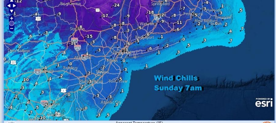
Wind Chills Below Zero Warmer Next Week

Weather in 5/Joe & Joe Weather Show Latest Podcast
Brutal Cold Tonight Single Digits to Near 10
Wind Chills Below Zero Warmer Next Week
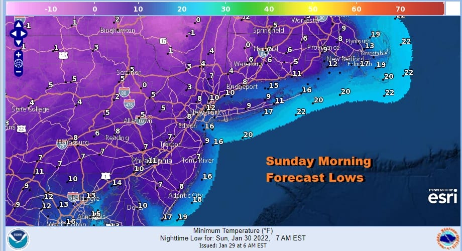
Our major winter storm that could be called the Blizzard of 2022 for coastal areas from Delaware to Maine is now beginning to move away. The swirl on the satellite covering the Northeast US is the upper low that formed and created the burial that occurred. It is now lifting northeastward and it leaves behind a brutally cold air mass. Lows tonight will be in the single digits to near 10 degrees.
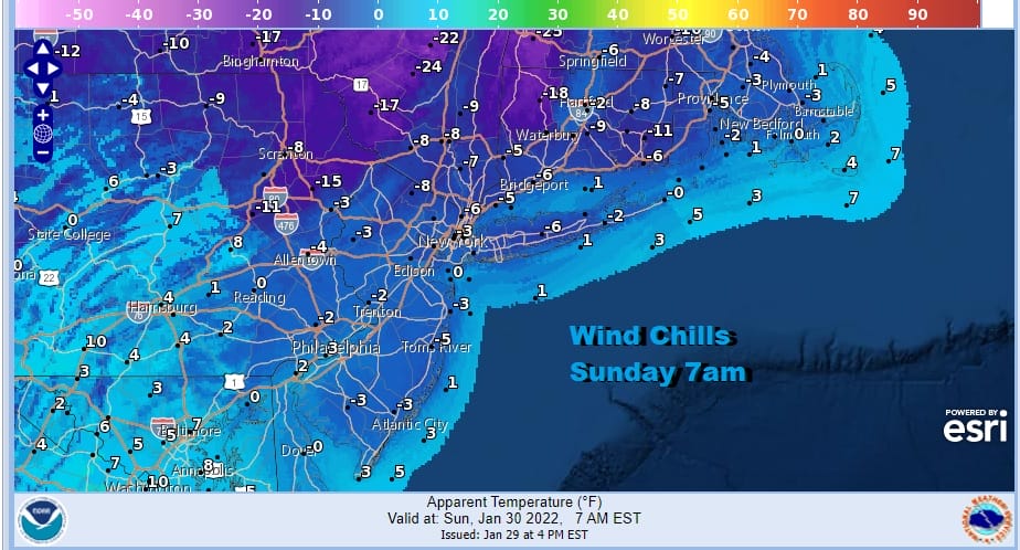
What will make it worse is the 20 to 30 mph winds with some higher gusts that will create wind chills that will be below zero Sunday morning. Arctic air from Canada will be overhead Sunday. Winds will ease a bit on Sunday but there will still be a breeze most of the day. Even though we should see a good deal of sunshine, temperatures will make back to the mid and upper 20s by the end of the day. The radar shows the heavy snow is now in Southeastern New England and that will pull out later this evening leaving 20 to 30 inch snow amounts there when it is all said and done.
SATELLITE

WEATHER RADAR

Winter takes a bit of a break for a few days next week. We should warm up into Thursday before we have to deal with the next round of changes. Monday and Tuesday temperatures will continue to move slowly higher. It would warm up faster but high pressure builds in Northeastern New England keeping an onshore flow and holding some colder air in. Highs will reach into the 30s Monday and and mid to upper 30s on Tuesday. Monday should be a nice day with sunshine. Clouds could be an issue Tuesday into Wednesday because of an onshore flow and weak low pressure in the ocean to our south. We are not expecting any precipitation unless some drizzle or light rain comes in Tuesday night into Wednesday. Wednesday we should warm up into the 40s with clouds around. Thursday will be ahead of the next cold front. Perhaps we will get some sun early before clouds arrive as a cold front approaches. Highs will reach the 50s before the front passes.

The pattern is not conducive for winter storms like what we just had. It is one where things will be changing as weather systems move along. This doesn’t mean that we are free from winter weather risks. Thursday’s front will move through and then it will stall to our south. We will have a wave that will then develop and move along the front. What could make this an issue is a very large and very cold arctic high that drops into the Great Lakes and moves into Eastern Canada.

It is timing out with the stalling front and the developing wave. Overrunning moisture will move along it so we will need to watch how far south the cold air gets. Models have been hinting around at this sort of idea for the last few days. The deciding factor is whether the upper high or ridge off the southeast coast is overdone by the GFS. Other models like the Canadian and the European show a flatter weaker ridge and that could make cold air more important and allow it to drain southward as precipitation moves in Thursday night and Friday. It will be something to keep an eye on. If the ridge is correct as modeled that the front will come through with rain and then it will just turn colder and drier behind it but if it is weaker, that could open the door to the possibility of rain to freezing rain and then maybe to snow before it is. At the moment this is just speculation but it is something to keep a side eye on it.
BE SURE TO DOWNLOAD THE FREE METEOROLOGIST JOE CIOFFI WEATHER APP &
ANGRY BEN’S FREE WEATHER APP “THE ANGRY WEATHERMAN!
MANY THANKS TO TROPICAL TIDBITS & F5 WEATHER FOR THE USE OF MAPS
Please note that with regards to any severe weather, tropical storms, or hurricanes, should a storm be threatening, please consult your local National Weather Service office or your local government officials about what action you should be taking to protect life and property.


