Blocking Pattern Emerges As March Nears

Blocking Pattern Emerges As March Nears
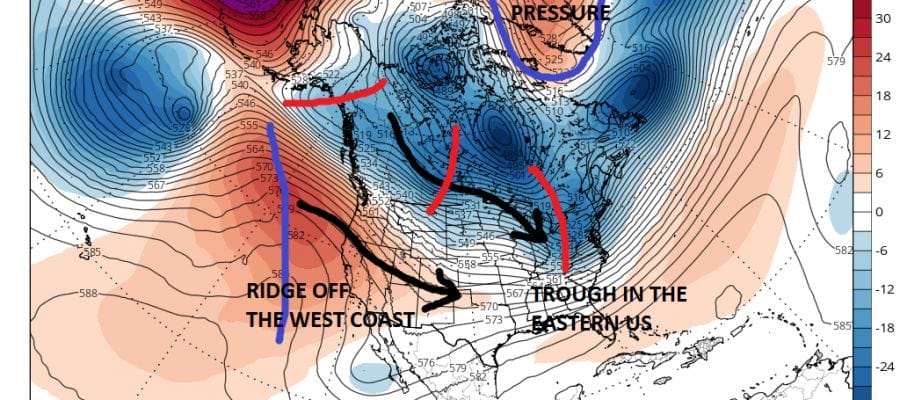
This has been a very odd year in that we have seen 2 10 inch plus snowfalls in our area this winter and both storms along with several smaller systems came in unfavorable upper air pattern set ups. I am saying this to illustrate that probably for the first time this entire winter we are going into what is usually a more favorable pattern yet the opposite is true here. Even the most favorable pattern setup may not yield the results you want or expect. With that said all the weather models in one form or another have been signalling such a pattern flip yet this is no guarantee. The winter has been basically one of 2 weeks on three weeks off and we are on course for another one of those two week on patterns. If something is going to happen from standpoint of cold and snow, this is probably the last chance before the natural warming that occurs in the early spring overtakes any cold air that remains.
BLOCKING PATTERN EMERGES GFS MODEL UPPER AIR VIEW TONIGHT
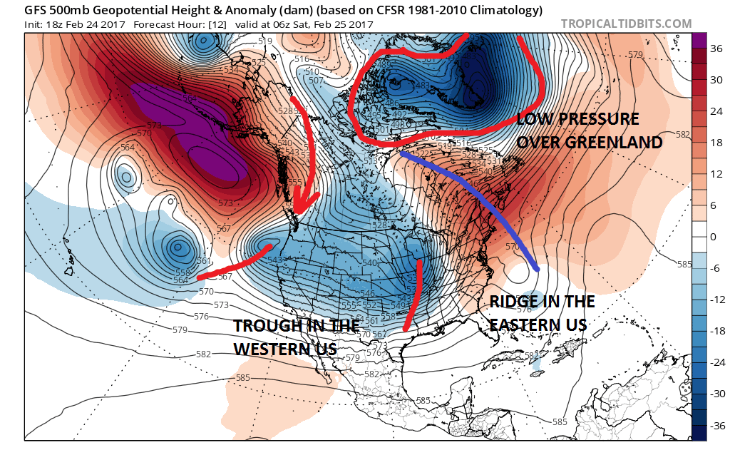
Here is a look at the upper air pattern at the moment and it could not possibly be worse for winter weather lovers though it is wonderful for those who like record highs. We have a trough in the west, ridge in the east and low pressure over Greenland. However in the next 7 days all the models undo all of this and we go to a new look in the upper air scheme across North America.
BLOCKING PATTERN EMERGES GFS MODEL FORECAST FRIDAY MARCH 3, 2017
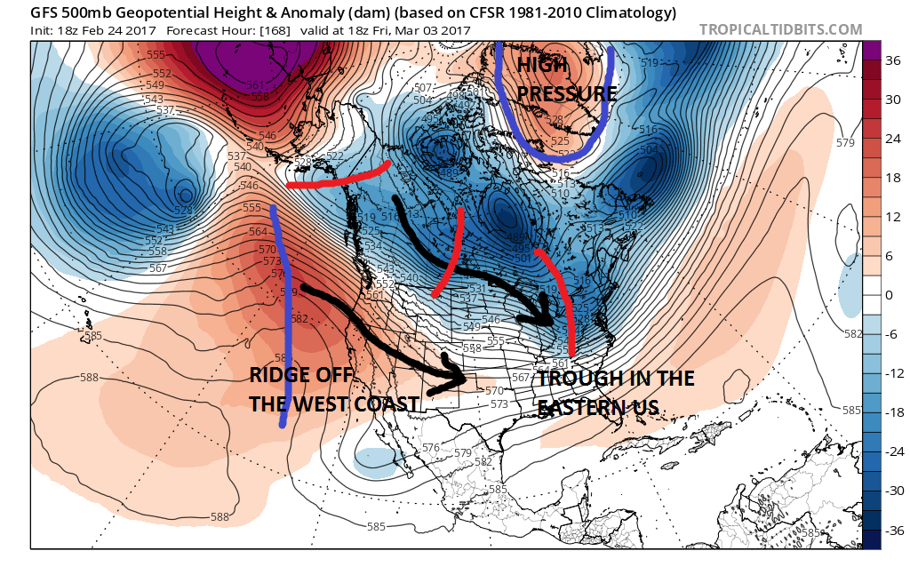
For the first time all winter we have a strong blocking high that is forecast to build over Greenland. This is an ideal spot for a cold flow to set up across North America and into the Northeast. The trough in the west is gone and replaced by a flat ridge. The red lines show upper air disturbances moving southeastward in the northwest flow. Beginning next Friday with the first system approaching and last through at least March 12th or 13th, I think there will be one or two opportunities for some cold and snow. Now which system IF any of them become problematic remains to be seen. It is quite possible that none of these systems creates any issues other than cold fronts passing through. If the block is overdone, than storm systems will like track to our north. If the block is stronger than modeled these systems go by to our south and create setups for snow. Right now it would seem to me that one of these systems will attempt to take a track that would produce some snow. But at the moment it is impossible to point to anything specific. The GFS model holds the blocking signature right into mid March which would suggest a colder than average temperature scheme developing next weekend. One thing I feel strongly about at this point is that the areas that have received average or above average snowfall (New Jersey north of Rte 78, NYC, Long Island, Southeast NY, and Southern New England are far more likely to see a chance of snow in this pattern than areas to the south. This puzzle will remain unresolved for quite awhile yet.
MANY THANKS TO TROPICAL TIDBITS FOR THE WONDERFUL USE OF THE MAPS

GET JOE A CIGAR IF YOU LIKE!
SNOW REMOVAL COMPANIES FOR YOUR WINTER NEEDS
LONG ISLAND ROCKLAND COUNTY Connecticut

![]()

ROCKLAND COUNTY TRI STATE SNOW REMOVAL JOHNSTOWN PA


FiOS1 News Weather Forecast For Long Island
FiOS1 News Weather Forecast For New Jersey
FiOS1 News Weather Forecast For Hudson Valley
NATIONAL WEATHER SERVICE SNOW FORECASTS
LATEST JOESTRADAMUS ON THE LONG RANGE
Weather App

Don’t be without Meteorologist Joe Cioffi’s weather app. It is really a meteorologist app because you get my forecasts and my analysis and not some automated computer generated forecast based on the GFS model. This is why your app forecast changes every 6 hours. It is model driven with no human input at all. It gives you an icon, a temperature and no insight whatsoever.
It is a complete weather app to suit your forecast needs. All the weather information you need is right on your phone. Android or I-phone, use it to keep track of all the latest weather information and forecasts. This weather app is also free of advertising so you don’t have to worry about security issues with your device. An accurate forecast and no worries that your device is being compromised.
Use it in conjunction with my website and my facebook and twitter and you have complete weather coverage of all the latest weather and the long range outlook. The website has been redone and upgraded. Its easy to use and everything is archived so you can see how well Joe does or doesn’t do when it comes to forecasts and outlooks.
Just click on the google play button or the apple store button on the sidebar for my app which is on My Weather Concierge. Download the app for free. Subscribe to my forecasts on an ad free environment for just 99 cents a month.
Get my forecasts in the palm of your hand for less than the cost of a cup of Joe!
![]()
