Blizzard Warning Snow Rapidly Moving Northward
The developing storm continues to gain momentum as we see a very impressive picture on the satellite loop below. The cloud structure is amazing as low pressure begins to reform along the Carolinas. Snow continues to advance northward as the radar shield continues to expand at a rapid rate. The advancement of the snow coincides with the NAM models depiction of what it is forecasting so we will continue to go with that model. It picked up on this 3 days ago and was the one model to show with consistency that the northern extent of the snow shield would wind up farther north than was indicated by the global models like the GFS and European. We will watch to see if that trend continues overnight.

Blizzard Warning Snow Rapidly Moving Northward Radar Loop

Blizzard Warning Snow Rapidly Moving Northward..OUTLOOK FOR OVERNIGHT
Snow will spread across New Jersey and heavy snow will be moving into Southeast Pennsylvania shortly. By midnight it should be snowing hard in Southeast Pennsylvania and Southern New Jersey while it gets ready to start in Northern New Jersey and New York City around midnight. Long Island will start around 1am from west to east and then the Hudson Valley and Northwest New Jersey around 2 am or so.
Saturday we will see heavy snow and blizzard conditions. Short term models are forecasting a mega band of snow across Central New Jersey into Long Island during the mid morning to mid afternoon time frame over this area and we will see how far north it gets. In southern areas the snow on the backside of the low will be underway and that will add additional accumulations.
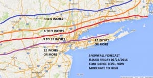
I’ve made no changes to the snowfall forecast but I want to emphasize that we may finish at the high end of estimates and possibly exceed them in Northern Areas. We will make any adjustments tonight once the new models make their appearance.
NATIONAL WEATHER SERVICE SNOW FORECASTS
LATEST JOESTRADAMUS ON THE LONG RANGE
Weather App
Winter is here! Don’t be without Meteorologist Joe Cioffi’s weather app. It is a complete weather app to suit your forecast needs. All the weather information you need is right on your phone. Android or I-phone, use it to keep track of all the latest weather information and forecasts. This weather app is also free of advertising so you don’t have to worry about security issues with your device. An accurate forecast and no worries that your device is being compromised.
Use it in conjunction with my website and my facebook and twitterand you have complete weather coverage of all the latest weather and the long range outlook. The website has been redone and upgraded. Its easy to use and everything is archived so you can see how well Joe does or doesn’t do when it comes to forecasts and outlooks.
Just click on the google play button or the apple store button on the sidebar for my app which is onMy Weather Concierge. Download the app for free. Subscribe to my forecasts on an ad free environment for just 99 cents a month.
Get my forecasts in the palm of your hand for less than the cost of a cup of Joe!


