Blizzard Warning NYC Long Island & Most of New Jersey
BLIZZARD WARNING IN EFFECT FOR NEW YORK CITY LONG ISLAND AND ALL OF NEW JERSEY SOUTH OF ROUTE 80
WINTER STORM WARNING FOR NORTHWEST NEW JERSEY EXCEPT SUSSEX COUNTY
WINTER STORM WARNING FOR WESTCHESTER COUNTY
WINTER STORM WATCH FOR SUSSEX COUNTY
WINTER STORM WATCH FOR CONNECTICUT SOUTH OF ROUTE 84
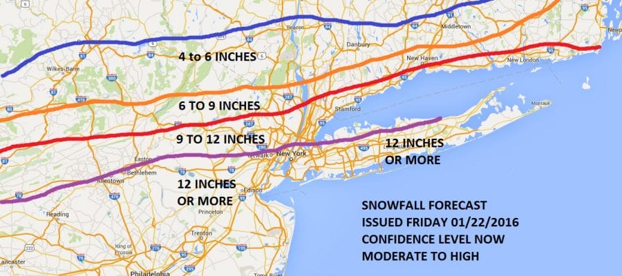
My new snow forecast map is up. Based on the overnight runs and now the latest runs of the NAM & GFS which continue to show a decided trend of increasing precipitation further north, plus strong support from the European, I have raised snow amounts and moved Long Island and Southern areas of New York City to 12 inches or more. Note that the lines are not exact (No one can nail those) but you get the idea. Also do notice that the lines remain very very tight so you won’t have to go far to get lower amounts.
The areas to the north and west of New York City remain a huge forecast problem because there is upside surprise possibilities there. The Nam model is the furthest north and most aggressive with 1 foot plus amounts well up to at least route 84 but for now we will stay with these numbers.
Blizzard Warning means heavy snow and strong winds for at least several hours and really doesn’t depend on snow totals being over 1 foot. With srong winds along the coast gusting to 50 mph or more there will be blizzard conditions with zero visibility Saturday into Saturday night.
I will address Coastal Flood Watches in a separate post.
BLIZZARD WARNING SATELLITE & RADAR

Satellite and radar show the storm moving along at a fast clip. The Nam model has snow reaching New York City by this evening which seems a bit fast but it could certainly arrive after midnight. I’m going to watch closely how fast the snow gets into Southern New Jersey and Southeastern Pennsylvania as a tip off for how close the NAM model is. The comma shape on the satellite is very impressive as is the wall of radar echos coming up from the south and now moving into Virginia


Note the squall line of thunderstorms on the radar across the deep south. This is going to be record breaking snow storm for much of the Middle Atlantic region.
NATIONAL WEATHER SERVICE SNOW FORECASTS
LATEST JOESTRADAMUS ON THE LONG RANGE
Weather App

Winter is here! Don’t be without Meteorologist Joe Cioffi’s weather app. It is a complete weather app to suit your forecast needs. All the weather information you need is right on your phone. Android or I-phone, use it to keep track of all the latest weather information and forecasts. This weather app is also free of advertising so you don’t have to worry about security issues with your device. An accurate forecast and no worries that your device is being compromised.
Use it in conjunction with my website and my facebook and twitterand you have complete weather coverage of all the latest weather and the long range outlook. The website has been redone and upgraded. Its easy to use and everything is archived so you can see how well Joe does or doesn’t do when it comes to forecasts and outlooks.
Just click on the google play button or the apple store button on the sidebar for my app which is onMy Weather Concierge. Download the app for free. Subscribe to my forecasts on an ad free environment for just 99 cents a month.
Get my forecasts in the palm of your hand for less than the cost of a cup of Joe!

![]()


