Better Day Sunshine Breezy Colder Weather Dry Week Ahead No Major Storms

Weather in 5/Joe & Joe Weather Show Latest Podcast
Better Day Sunshine Breezy Colder Weather Dry Week Ahead No Major Storms
Our storm has departed and sits in the Gulf of Maine and headed for Nova Scotia and Newfoundland. We are looking at a chilly day ahead and while we will have some sunshine, we are still under the influence of an upper trough over the Eastern US that still has a bit of work to do over the next couple of days.

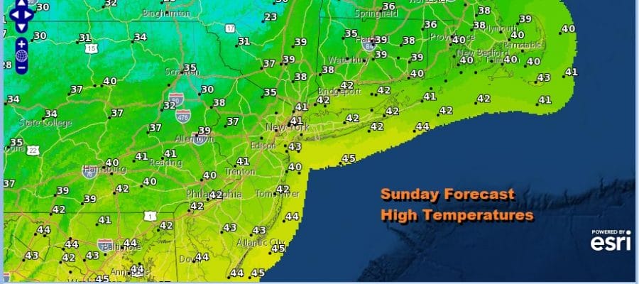
Temperatures today are going to struggle with highs in the upper 30s and lower 40s. There will also still be a bit of a gusty wind from the northwest giving the chill an extra bite but the wind will not be out of control. There will also be some clouds around mixing in with the sun and we can see there are clouds in the Northeast on the satellite view. As far as precipitation goes, even though we do have upper air systems moving through over the next couple of days, they are on the weak side and there should be no precipitation on the radars for not only the next few days but probably this entire week.
SATELLITE

REGIONAL RADAR

Lows tonight will be in the mid to upper 20s under a partly to mostly clear sky. The next 3 days look to be chilly with a mix of sun and clouds. Daytime highs each day Monday through Wednesday will be in the upper 30s and lower 40s. Nighttime lows will be mostly in the 20s.

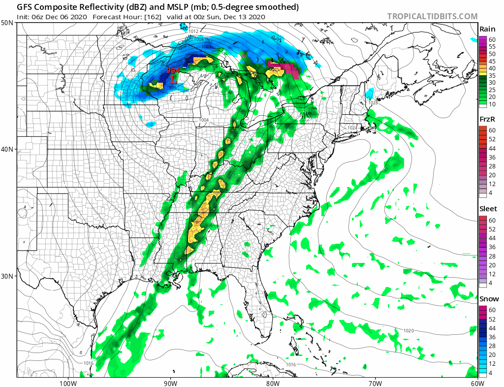
The last in a series of weather systems here in the east will be passing off the Carolinas on Monday. It may brings some snow over parts of Western North Carolina and Southern Virginia but other than some high clouds pushing northward on Monday there are no impacts here. The low heads offshore to the east northeast. This is really the only system in the Eastern US this week. After Wednesday the cold air abates and temperatures moderate with some sunshine for Thursday and Friday. Highs will reach the upper 40s and lower 50s both days.
Next weekend looks like it will be split in two with a cold front approaching. Saturday will be warmer with highs in the 50s but it should be dry. It looks like a cold front will produce rain on Sunday with highs in the 50s to near 60. Everything is moving along and once the front passes it turns colder and drier for early next week. No major storms are on the horizon for the next 7 to 10 days.
BE SURE TO DOWNLOAD THE FREE METEOROLOGIST JOE CIOFFI WEATHER APP &
ANGRY BEN’S FREE WEATHER APP “THE ANGRY WEATHERMAN!
MANY THANKS TO TROPICAL TIDBITS FOR THE USE OF MAPS
Please note that with regards to any severe weather, tropical storms, or hurricanes, should a storm be threatening, please consult your local National Weather Service office or your local government officials about what action you should be taking to protect life and property.


