
Best Day of the Week, Thanksgiving Wind Snow Rain Weekend
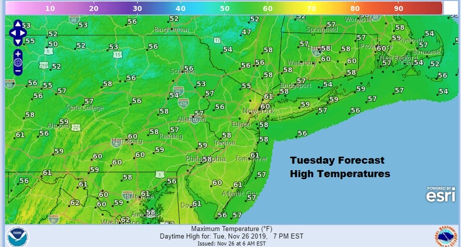
There is no question that today is the best day of the week weather wise as we will have a nice sunny and a relatively mild day for a change. Temperatures will actually be a little above normal as highs reach the mid 50s to near or even over the 60 degree mark in some places. Other than a few passing clouds there are no weather issues at all. A major storm coming out of the Central Rockies is heading for the Great Lakes and isn’t anywhere close to us yet. it should be fine tonight too with clear skies to start giving way to arriving clouds by morning. Lows will be mainly in the upper 30s to middle 40s. The satellite picture this morning isn’t showing much in the way of clouds across the Northeast US and the regional radar is nice and quiet.
SATELLITE

REGIONAL RADAR

Wednesday is the big travel day ahead of Thanksgiving and while weather in the west is not good with a second major winter storm underway, in the East it is a lot easier. look for clouds and breezy conditions as a cold front approaches. There could be a passing shower or two but not much more than that. Highs will be in the 50s. We should clear out nicely Wednesday night with lows in the 30s to lower 40s and the wind will be picking up from the northwest.
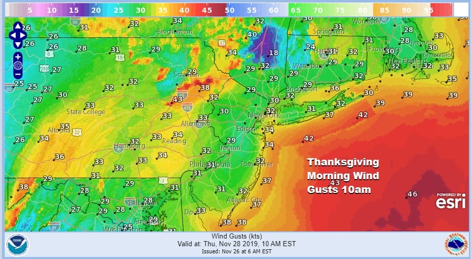
Thursday is Thanksgiving Day and while it will be dry with some sunshine, it will also be windy especially during the morning with northwest winds of 20 to 30 mph with gusts near 40 mph at times. This will have some impacts on parade goers and on the Thanksgiving Day parade itself regarding the loved balloons. Overdress if you are going and prepare for those gusty winds and temperatures that will feel like the 30s. Highs Thursday will be in the 40s as winds ease later in the day. Friday will be a nice day with sunshine as high pressure funnels dry air from Eastern Canada southward while a strong storm sits to the east. Winds will still be on the gusty side with highs in the 40s. There are no weather issues for the hordes of shoppers heading to wherever hordes of shoppers head to
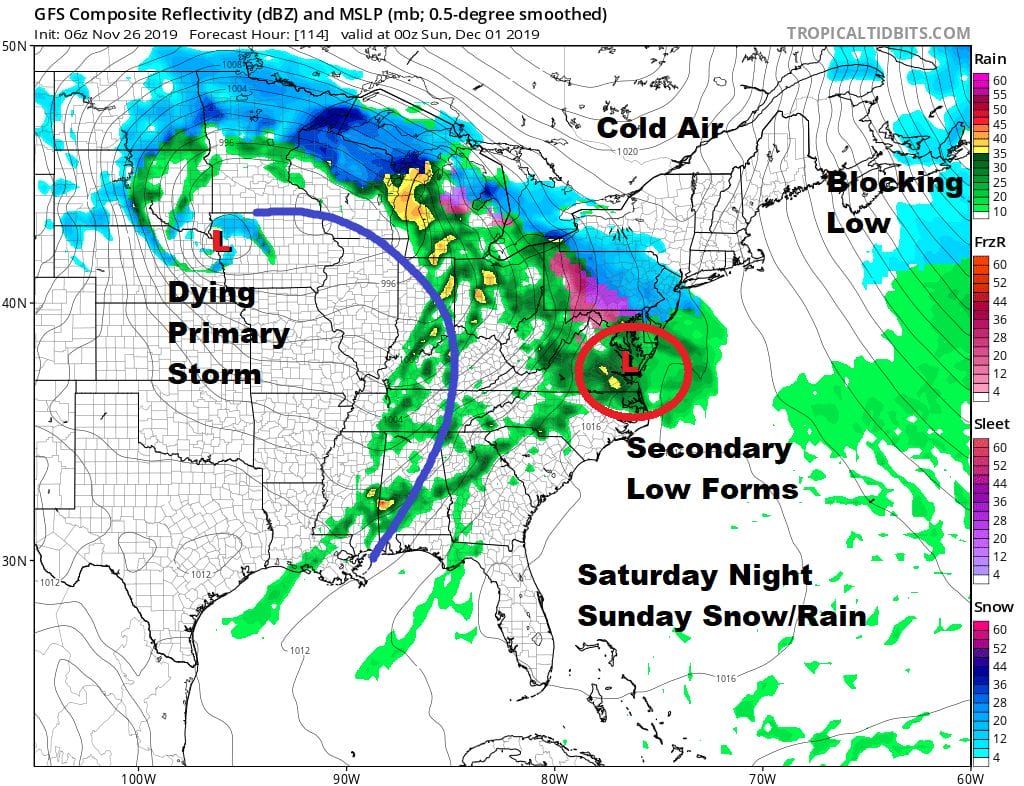
Saturday we will see increasing clouds and we have what could be our first solid accumulating snow threat of the season. A major storm coming out of the west heads into the upper Midwest. We have a blocking pattern all set up with low pressure stalled near Newfoundland and higher pressures all across Southern Canada. The low will weaken and then a new low will form (a secondary) somewhere in Eastern Virginia or Chesapeake Bay and head northeast or east northeast from there. The block to the east is strong and this system will be slow to move.
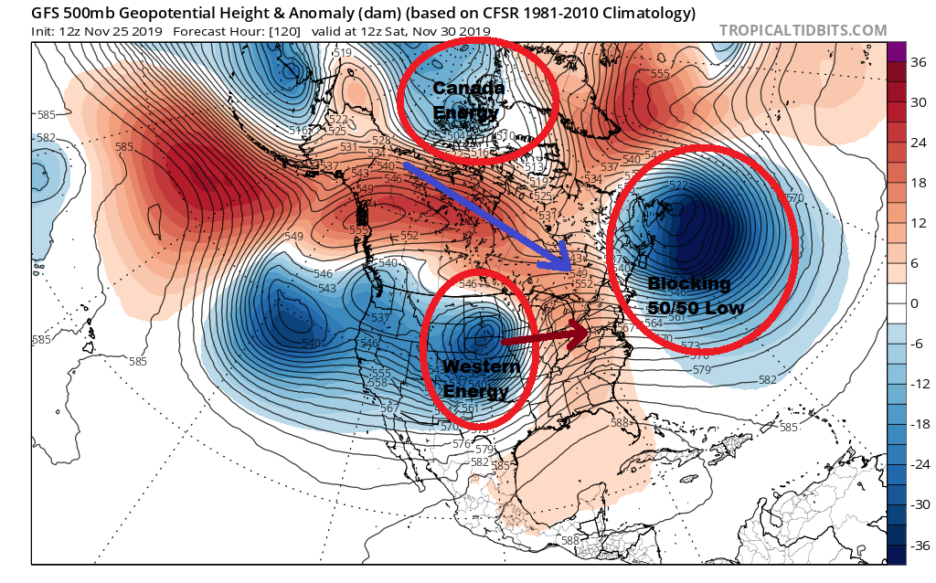
At this stage of the game I think that we are going to see some snow out of this though how much is a question for two days from now and not today. This set up 2 weeks from now or even a week from now when average temperatures are several to 6 degrees lower than they are now would make for an easier outcome. Everything in the atmosphere is going to be borderline near the immediate coast but inland areas may be that critical 1 to 2 degrees colder that will make a big difference here. Snow will likely continue through Sunday and into Sunday night since this system will be crawling to the northeast before moving out Monday morning. Needless to say there will be travel issues as everyone heads back from the Thanksgiving holiday.
APP users (both apps are free) can check National Weather Service snow forecast maps this holiday weekend from Maine to Georgia (though you won’t need it for areas south of Maryland) that update automatically. Additional winter weather coverage is available on my weather platform on Patreon. Members can message me anytime for a quick response.
BE SURE TO DOWNLOAD THE FREE METEOROLOGIST JOE CIOFFI WEATHER APP &
ANGRY BEN’S FREE WEATHER APP “THE ANGRY WEATHERMAN!
MANY THANKS TO TROPICAL TIDBITS FOR THE USE OF MAPS
Please note that with regards to any severe weather, tropical storms, or hurricanes, should a storm be threatening, please consult your local National Weather Service office or your local government officials about what action you should be taking to protect life and property.


