Beautiful Weekend Weather Continues Sunday Rain Returns Early Tuesday
The first half of the weekend has been a beautiful one with lots of sunshine just about everywhere and we seem to have outperformed temperature wise a bit as highs reached the upper 40s and lower 50s this afternoon. This was a little higher than advertised but that I’m sure will get no complaints. The satellite picture shows clear skies everywhere in the Eastern US all the way back to the Mississippi River so we will have clear skies tonight and with light winds and most lows in the 20s except for lower 30s in warmer urban centers. Radars are nice and quiet as well with no weather issues to worry about.
SATELLITE
REGIONAL RADAR
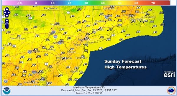
With no issues to worry about for Sunday we can just sit back and enjoy another day of sunshine and warm temperatures. Since we were able to take out today’s forecast highs by a few degrees I think we may be able to do the same thing on Sunday unless some high clouds burst on to the scene and cut back on sunshine. Temperatures at the very least should make the forecast numbers below and with a little luck we might add a few degrees to these numbers.
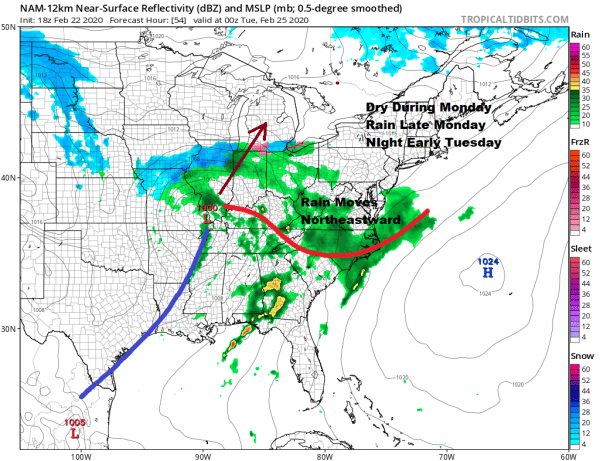
Monday I think will be mostly dry as the next weather system moving out of the Plains does so in rather slow fashion. This should keep rain out of here through Monday evening. Monday itself will likely be a day of sunshine and arriving clouds.
It is hard to make a case for much rain here on Tuesday with this first low heading to our west and not exactly rocking our socks off as far as development is concerned. The main energy in the upper air is to the west and won’t swing into the Eastern US until Wednesday. At this point a more important low is likely to develop and strengthen as it heads into Canada.
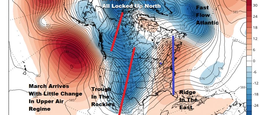
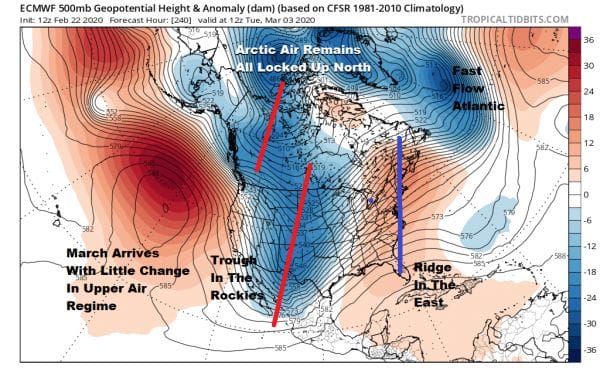
This will likely bring more rain Wednesday into Wednesday night for the Northeast and Northern Mid Atlantic States before it turns colder and dry for late in the week and and the weekend. For snow lovers the days grow short and the pattern remains absolutely unyielding. I was hoping that a window of opportunity would open in early march for a handful of days but we may just as well toss that possibility out the window at this point.
Weather models have been doing what they have been doing for since late December. They hint at a weather pattern change for a few days and then it goes right back to the same scheme that it has been locked up in since before Christmas. The opera is over folks. The fat lady has sung! Even if the weather pattern were to change later in the month, by the time you get all the chess pieces in the right spots (if you do) it will be nearly April. At that point warm it up and bring on spring!
BE SURE TO DOWNLOAD THE FREE METEOROLOGIST JOE CIOFFI WEATHER APP &
ANGRY BEN’S FREE WEATHER APP “THE ANGRY WEATHERMAN!
MANY THANKS TO TROPICAL TIDBITS FOR THE USE OF MAPS
Please note that with regards to any severe weather, tropical storms, or hurricanes, should a storm be threatening, please consult your local National Weather Service office or your local government officials about what action you should be taking to protect life and property.


