Beautiful Late Summer Weather Into the Weekend
Tropical Storm Fiona Heads For Leeward Islands

Tropical Storm Fiona is making its way westward toward the Northern Leeward Islands where we have tropical storm warnings in effect. Fiona is a bit disorganized as the satellite shows. Convection is solid on the east side of the system but the center of Fiona is mostly exposed with little weather going on west, south and north of the center. There is some wind shear going on and that will likely limit strengthening at least for now.

The 11am Thursday September 15th forecast shows a mostly west track for the next several days bringing the tropical storm over the Northern Leeward Islands, Puerto Rico, and close to the Domican Republic. If the storm does not strengthen much from here, heavy rains will likely be the biggest threat. Longer term a turn to the northwest seems likely early next week but any idea of a threat to the US is a long way off and weather models remain all over the place regarding strength timing and track not only for Fiona, but for weather across the US. There are way too many puzzle pieces. We will explore more this afternoon on Patreon as well as tonight on the Joe & Joe Weather Show.

In the meantime we have a beautiful air mass covering not only much of the Northeast and Mid Atlantic but just about everywhere of the Mississippi River. The satellite shows mostly clear conditions and we will remain sunny this afternoon. Temperatures will probably settle in the middle 70s in most places though some areas north and west of the coast will be in the upper 60s and lower 70s for highs.
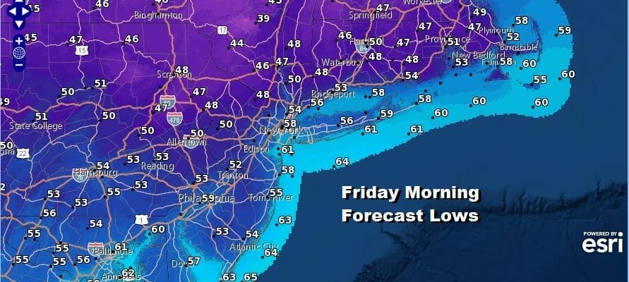
Tonight will be nice and skies will be mostly clear. We will see some of the coolest temperatures in the area since June. Most lows by morning along the coast and in warmer urban locations will be in the low to mid 50s while inland areas will likely see many areas in the 40s!
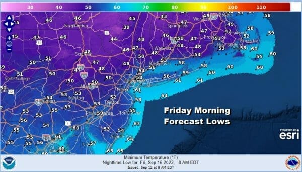
Friday will be another mostly sunny nice day with highs in the mid to upper 70s. High pressure will begin to reform over the Mid Atlantic coast and that will keep humidity levels low into Saturday Tonight will be another clear night with cool temperatures. Most lows in warm urban centers will be near or just over 60 with 50s nearby and 40s again inland.

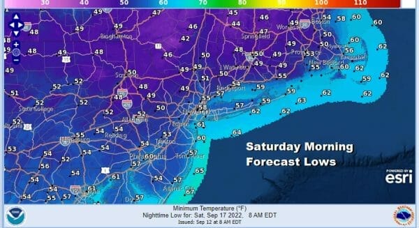
Saturday with the high offshore temperatures will start to rise but because much of the Eastern US is not overly humid, humidity levels will only slowly move up and Saturday humidity should still be rather reasonable. Highs Saturday will be back into the 80s away from the ocean. Skies will be partly to mostly sunny with no other issues.

Sunday will be warmer and techinically it will be more humid. However the dew points will only be climbing back to the low 60s at worst so while yes it will be more humid, it will be reasonable and bearable. Skies should be mostly sunny to at worst partly sunny. There is a backdoor cold front in Northern New England but that should only get so far south and stall out before going back north. No rain is forecast through the weekend.
BE SURE TO DOWNLOAD THE FREE METEOROLOGIST JOE CIOFFI WEATHER APP &
ANGRY BEN’S FREE WEATHER APP “THE ANGRY WEATHERMAN!
MANY THANKS TO TROPICAL TIDBITS & F5 WEATHER FOR THE USE OF MAPS
Please note that with regards to any severe weather, tropical storms, or hurricanes, should a storm be threatening, please consult your local National Weather Service office or your local government officials about what action you should be taking to protect life and property.


