Arriving Clouds Showers Overnight Windy & Colder Weather Starts the New Week
Low pressure is moving across Eastern Canada with a trailing warm front that will approach later this evening quickly followed by a cold front early Sunday morning. Ahead of all this today we will see any sunshine give way to arriving clouds. The lack of sunshine is going to keep temperatures from rising much this afternoon as highs reach the upper 40s and lower 50s in most places. Rain should hold off until dark and the spread over Eastern Pennsylvania to Southern New England during this evening.
SATELLITE WITH LIGHTNING STRIKES
WEATHER RADAR
This is not going to be much of a rain maker as the system has limited moisture, though for New England the moisture will increase as the low center strengthens overnight and Sunday. Rainfall forecast amounts for the most part are under a quarter of an inch and south of New York City it could be less than a tenth of an inch. Southeastern New England and points north and northeast could pick up a half inch or more.
Sunday will be a day of improving weather conditions with decreasing clouds and increasing sunshine. Also increasing will be the wind from the northwest which will build to 20 to 30 mph with some higher gusts. Temperatures Sunday will probably reach their highs earlier in the day as progressively colder air moves southeast across New York State and New England, turning on the lake effect snow machine. Most highs will be in the 50s and then drop to the 30s everywhere by Monday morning.
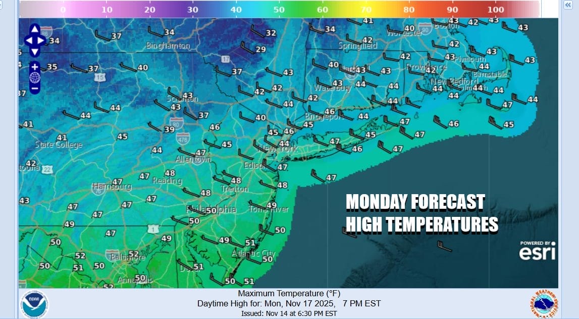
Strong winds will continue Monday as the storm system strengthens over Atlantic Canada and the pressure gradient remains rather tight. Lake effect snows will begin to diminish later in the day Monday. Along the Coastal Plain we should see a fair amount of sunshine with some patchy clouds, gusty winds to 30 to 35 mph, and high temperatures that will be mostly in the 40s.
Chilly weather conditions will continue Tuesday through Thursday. Tuesday and Wednesday highs will be in the 40s. Thursday we could see a push to the upper 40s and lower 50s. Weak low pressure from Kansas will weaken as it moves eastward. We might see some clouds from this Tuesday but rain should fall apart before it gets anywhere close. Look for some sunshine Wednesday. Thursday a warm front and an onshore flow could bring a little rain but chances for rain are higher Friday.
BE SURE TO DOWNLOAD THE FREE METEOROLOGIST JOE CIOFFI WEATHER APP \\\&
ANGRY BEN’S FREE WEATHER APP “THE ANGRY WEATHERMAN!
MANY THANKS TO TROPICAL TIDBITS FOR THE USE OF MAPS
Please note that with regards to any severe weather, tropical storms, or hurricanes, should a storm be threatening, please consult your local National Weather Service office or your local government officials about what action you should be taking to protect life and property.