Arctic Air Pulls Out Week Ahead Outlook Waves of Rain Likely

Arctic Air Pulls Out Week Ahead Outlook Waves of Rain Likely
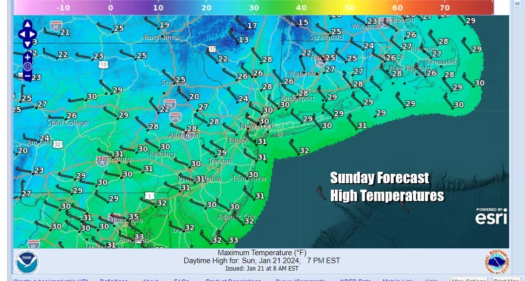
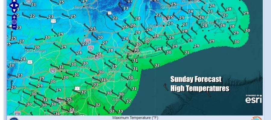
The arctic air that covers much of the Eastern US will begin to abate today as high pressure settles in the Southeast US. Winds will turn more westerly as the day wears on and we should see a fair amount of sunshine. Highs this afternoon will reach the upper 20s and lower 30s. This will be the last day of temperatures below the freezing mark during the day as the flow from the Arctic region and Northwest Canada is effectively shut of for the week ahead. Radars are quiet today and we do not expect any snow showers. Tonight we see a night of mainly clear skies with lows by Monday morning in the teens to near 20.
SATELLITE WITH LIGHTNING STRIKES

WEATHER RADAR

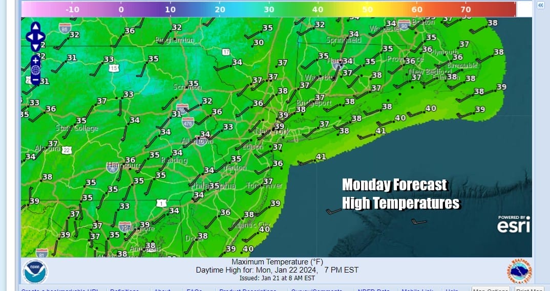
Monday will be a day of sunshine and some high clouds but temperatures will begin to bounce. High pressure to the south and a west wind will help us reach highs in the mid to upper 30s Monday afternoon. That is average for this time of year. Again this will be a day of no precipitation to worry about.
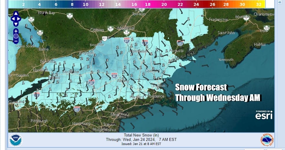
While we will see an uptrend in temperatures continue this week, it will be slow. Also the warm up is coming with wet weather as a flow of moisture from the Gulf States heads northeastward. The first of three waves of low pressure will head northeast Tuesday. At the same time we have cold highs moving across Southern Canada this week and into the weekend. This combination is not a problem for winter weather unless one of the cold highs to the north times out perfectly with low pressure coming out of the south.

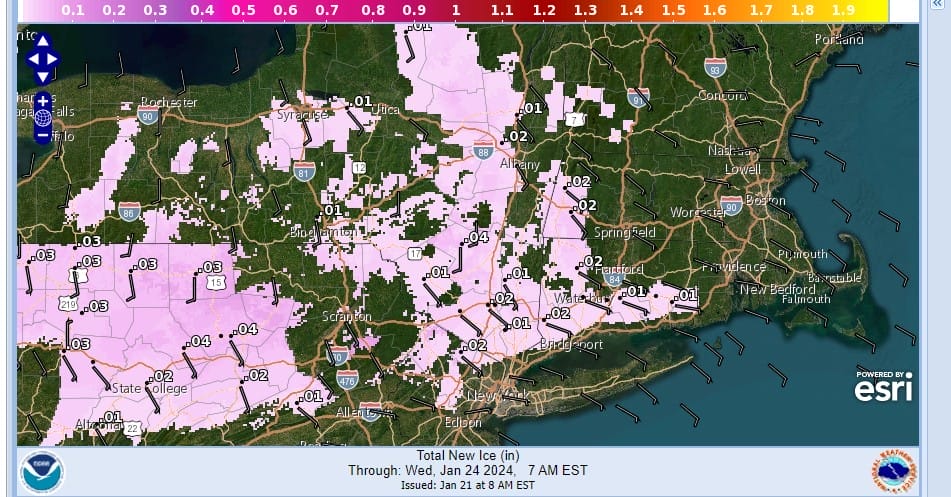
Tuesday we will be on the edge of a weather front that will cut across the Northeast. High pressure to the north has some cold air that will wedge into Upstate NY and New England. To the south warmer air but we are seeing a limited warm up develop. The result Tuesday will be lots of clouds. Across Upstate NY and into New England we will see light snow as well as some pockets of sleet and freezing rain developing. From Northern Pennsylvania and Northern New Jersey northward into the Hudson Valley as well as Southern New England, we could see pockets of cold air being trapped and that could result in some icing.
As far as temperatures go Tuesday we should see highs reaching into the 40s with the except of areas north and northwest of NYC and Philadelphia. Inland areas will see highs in the 30s and some areas could struggle to get above 32, setting up for some icing issues Tuesday evening and night.
Areas near the coast and points south through New Jersey and Southern Pennsylvania will see some rain developing later Tuesday into early Wednesday. However we see more rain developing as another wave of low pressure moves northeastward for Wednesday night into Thursday. A third wave of rain is likely Thursday night into Friday.

None of the systems for this week will be big precipitation producers as we are looking at rainfall amounts of around an inch to an inch and a quarter this week. However the South is going to see very heavy rainfall this week. Areas from East Texas and across the Gulf States will see rainfalls ranging from 1.5 inches to areas of 4 to 5 inches or more. This is going to go along way to releive drought conditions there.
BE SURE TO DOWNLOAD THE FREE METEOROLOGIST JOE CIOFFI WEATHER APP &
ANGRY BEN’S FREE WEATHER APP “THE ANGRY WEATHERMAN!
MANY THANKS TO TROPICAL TIDBITS FOR THE USE OF MAPS
Please note that with regards to any severe weather, tropical storms, or hurricanes, should a storm be threatening, please consult your local National Weather Service office or your local government officials about what action you should be taking to protect life and property.
(Amazon is an affilate of Meteorologist Joe Cioffi & earns commissions on sales.)


