Another Brutally Hot Day Severe Weather Risk Later Monday

The launching pad was set for blast off today when temperatures didn’t get below 80 in many cloations for overnight lows. It is another brutally hot day with sunshine taking highs again up to 95 to near 100 degrees in some places. This will match yesterday’s highs which were inside that range. This will also be the last day of the excessive heat but the humidity will remain high though Monday. A cold front will be approaching and this sets us up for a threat of severe weather Monday afternoon and evening. In the meantime today there isn’t much going on other than some blow off cloud cover from thunderstorms to the northwest. We don’t see anything more than a pop up shower or thunderstorm late this afternoon into tonight and the best chances for those are well inland.
SATELLITE

REGIONAL RADAR

Changes begin Monday as a cold front approaches and slows down to an absolute crawl on Monday. We will see highs in the 80s to perhaps near 90 in the warmest spots. Dew points will be in the 70s and a wave will be developing on that front as it goes. All of this lines up for the possibility of severe weather and the Storm Prediction Center continues to indicate a marginal risk for severe weather though I do believe that risk area is going to be elevated to slight risk come Monday morning.

it is also becoming evident that the cold front will have to wait for a second wave to develop and move through on Tuesday. This means that we not only have the risk for downpours and thunderstorms late Monday and Monday night but we could have more downpours at least into Tuesday afternoon before weather conditions genuinely improve late Tuesday or Tuesday night. Highs Tuesday will likely be just in the 70s to near 80 if this is indeed the case.
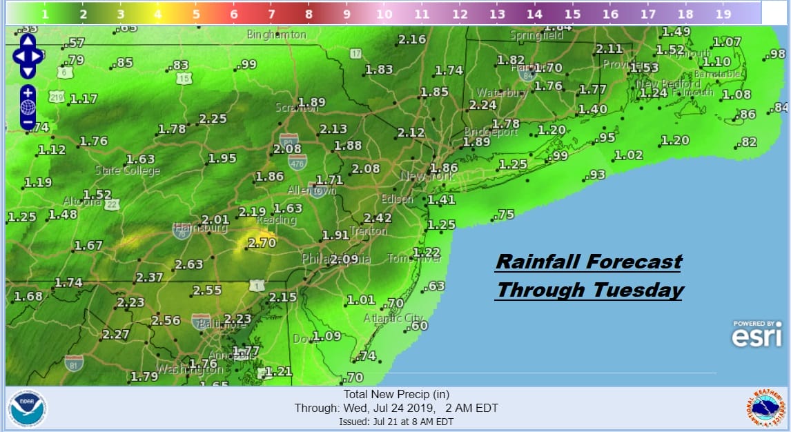
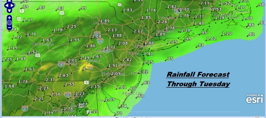
Between thunderstorms late Monday and more rain and thunderstorms into Tuesday the rainfall amounts could be significant and on the order of 1 to as much as 3 inches in some places. This will likely mean some flash flooding potential exists and it won’t take much rain to set it off.

Wednesday through Friday are shaping up to be three nice days with sunshine, comfortable humidity, and daytime highs in the low to mid 80s as high pressure from the Plains builds eastward across the US and any hot humid air remains suppressed to our south. At least the excessive heat and humidity will be long gone and we can enjoy some seasonal weather conditions later this week.
MANY THANKS TO TROPICAL TIDBITS FOR THE USE OF MAPS
Please note that with regards to any tropical storms or hurricanes, should a storm be threatening, please consult your local National Weather Service office or your local government officials about what action you should be taking to protect life and property.


