A Beautiful Sunday of Sunshine Week Ahead Cold Front Late Tuesday
Weather in 5/Joe & Joe Weather Show Latest Podcast
A Beautiful Sunday of Sunshine Week Ahead Cold Front Late Tuesday
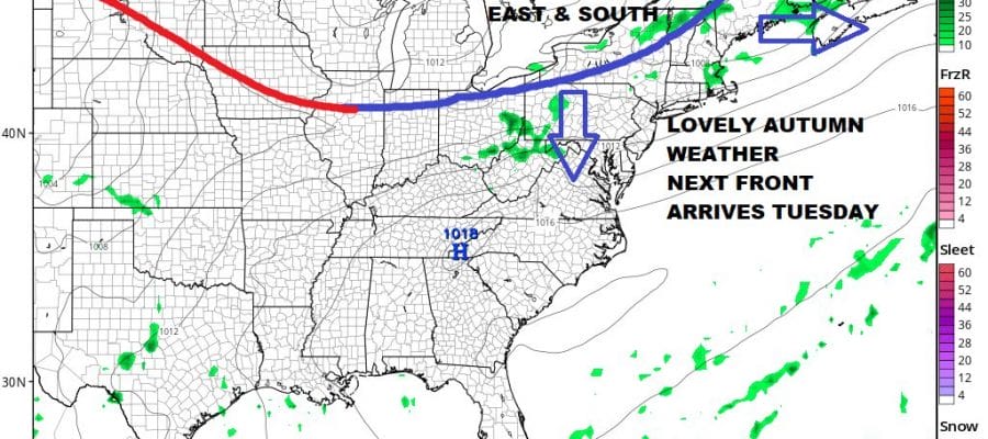
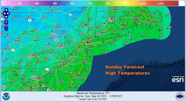
Autumn always seems to have its fair share of weekends and this one certainly will go down as the first of what hopefully will be many nice weekends. Low pressure is off the coast of Eastern New England and is funneling dry air southward. An upper trough has passed through and we will have lot sunshine today, very low humidity and highs in a range of 70 to 75 with some inland cool spots in the upper 60s. The radars are quiet except for rain in Eastern New England. There are no radar issues for Eastern Pennsylvania to Southern New England into Tuesday.
SATELLITE
WEATHER RADAR
Tonight will be nice and clear with most lows in the 50s. Monday will be another lovely day of sunshine with temperatures mostly in the 70s. It is a rather straight forward forecast with high pressure in the Carolinas in total control.
Tuesday brings the next cold front dropping southward from Eastern Canada and the Great Lakes. This is due to a deep upper trough strengthening just off the East Coast. When it passes through Tuesday afternoon there could be a couple of showers or even a stray thunderstorm but no severe weather is forecast. Tuesday’s highs will be in the 70s.
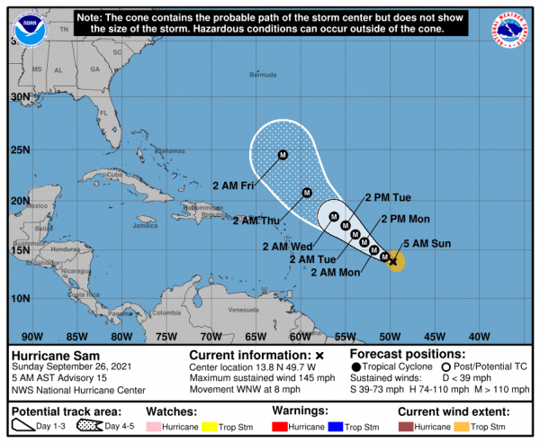
Once the front passes it drops southward and it sets us up for a dry and pleasant second half of the week. Low humidity and sunshine. Wednesday’s highs will be in the cool 60s to near 70 degrees and nights will be dropping to the upper 40s to mid 50s. Thursday looks good too with sunshine and highs in the 60s to near 70 degrees. Late this week Hurricane Sam will come into range to the southeast of Bermuda as blocking sets up in the Eastern US. It appears the block will be along the coast and just offshore which sends Sam northward offshore and close to Bermuda. There is still some uncertainty regarding the developing block and we will be focusing our attention on this in the coming days. Hurricane Sam is a category 4 hurricane with 145 mph winds and is moving slowly west northwestward.
Sam is a very small but powerful hurricane but it will pass north and east of the Leeward Islands and then continue northwestward from there. More on Sam and the long range will be available on Patreon later today.
BE SURE TO DOWNLOAD THE FREE METEOROLOGIST JOE CIOFFI WEATHER APP &
ANGRY BEN’S FREE WEATHER APP “THE ANGRY WEATHERMAN!
MANY THANKS TO TROPICAL TIDBITS & F5 WEATHER FOR THE USE OF MAPS
Please note that with regards to any severe weather, tropical storms, or hurricanes, should a storm be threatening, please consult your local National Weather Service office or your local government officials about what action you should be taking to protect life and property.


