Ida Rains On The Way
Flash Flood Watch Long Island Wednesday into Thursday Morning

Weather in 5/Joe & Joe Weather Show Latest Podcast
Ida Rains On The Way Flash Flood Watch Long Island Wednesday into Thursday Morning
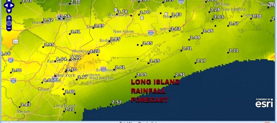
Long Island is under a flash flood watch for Wednesday into Thursday morning. The remnant low and rains from Hurricane Ida are headed our way and we will likely see a 3 to as much as 4 or even 5 inches of rain from this. The heaviest rains will fall late Wednesday afternoon and overnight into early Thursday morning before the rains exit to the east.

The wet summer has left the ground saturated and even though we have been dry for most of the last week, the humidity has been very high and there has not been much drying. We will likely see flooding in the usual suspect spots as well as some of the not so usual spots.
SATELLITE

We do have a dry day ahead of us today with high clouds already here. Last night’s cold front has now stalled just to our south and that sets the pathway for the remnant Ida low to move along. The low center itself will pass just to the south of Long Island and we will see a strong inflow of Atlantic moisture. Temperatures today will top in the 70s to near 80 and no rain is forecast.
WEATHER RADAR


Weather conditions will deteriorate Wednesday with showery rains moving in during the first part of the day and then a steady heavy drenching rain starting late Wednesday afternoon and lasting into Thursday morning. If Ida moves along the rains will be done by daybreak Thursday or shortly afterwards. Temperatures will be in the 70s on Wednesday. The models are similar in track but are about 3 or 4 hours different in the timing. The NAM model holds on to the rain for a few extra hours because it is slower than the others. We compromised the timing of the models ending it a little faster than the NAM indicates.

Weather conditions will start to improve late Thursday as skies begin to clear and the payoff here is a nice cool dry air mass that will build in. Temperatures Thursday will be just into the lower 70s and the Friday should be partly to mostly sunny and nice with low humidity and highs in the mid 70s.

The Labor Day holiday weekend is upon us and so far this summer, weather has not been kind to us on the last 2 holiday weekends. We will be addressing the holiday weekend forecast later today in a separate post.
BE SURE TO DOWNLOAD THE FREE METEOROLOGIST JOE CIOFFI WEATHER APP &
ANGRY BEN’S FREE WEATHER APP “THE ANGRY WEATHERMAN!

MANY THANKS TO TROPICAL TIDBITS & F5 WEATHER FOR THE USE OF MAPS
Please note that with regards to any severe weather, tropical storms, or hurricanes, should a storm be threatening, please consult your local National Weather Service office or your local government officials about what action you should be taking to protect life and property.