- Sunshine Sunday Nice Weather Most of the Week Ahead No Rain or Snow Forecast
Sunshine Sunday Nice Weather Most of the Week Ahead No Rain or Snow Forecast
[caption id="attachment_302175" align="aligncenter" width="595"] COUPON CODE "WINTER2324" GET 10% OFF (Tempest is an affilate of Meteorologist Joe Cioffi & earns commissions on sales.)[/caption]
Sunshine Sunday Nice Weather Most of the Week Ahead No Rain or Snow Forecast
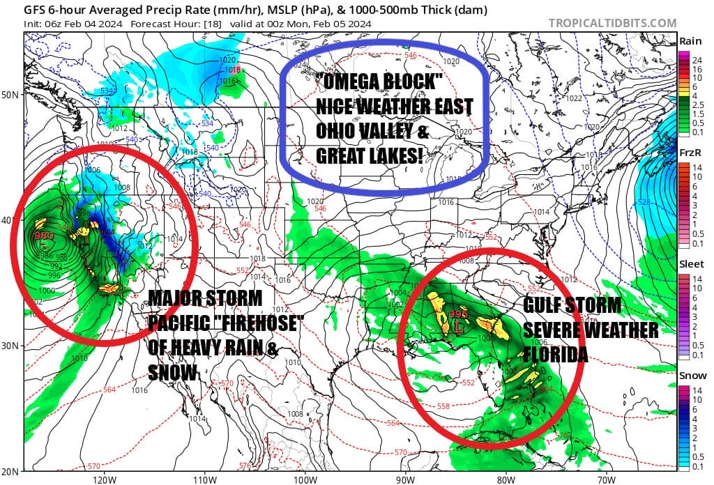
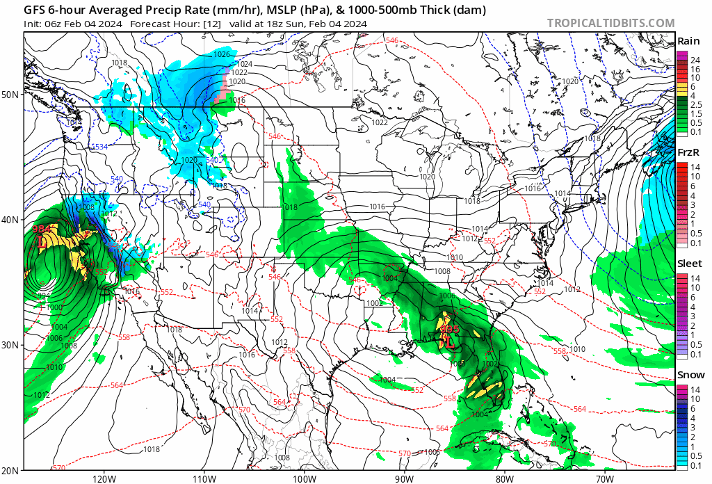
Sometimes being in a blocking pattern is a good thing and this is one of those times. We have an omega block Over Southern Canada and that is where high pressure is sandwiched in between two strong storm systems. One is the so called "atmospheric river" set up for California. That is really a strong low off the coast of California pumping a firehose of moisture into that state. Heavy rains of 6 inches or more are falling up and down the coast while inland in the mountains it is snow in feet. On the other side we have low pressure moving across the Northern Gulf of Mexico that is tracking so far south, it will actually redeveloip off along the Florida east coast and head out to see. Thunderstorms, and severe weather are forecast for Florida as well as heavy rain across the Gulf States. This low heads eastward and out to sea over the next couple of days.
SATELLITE WITH LIGHTNING STRIKES

WEATHER RADAR
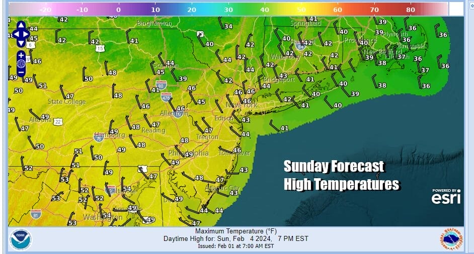
The omega block leaves the Northeast and Mid Atlantic states in a sweet spot of dry weather and sunshine for the next couple of days. Gloom and doom has transitioned over to nice weather until the block breaks down and that won't happen for another few days at least. So it is a sunny Sunday of sunshine and highs mostly in the low to middle 40s.
 There isn't much mystery to the outlook for the week ahead. The block will hold high pressure in the Eastern Canada and down the East Coast. The air is chilly but not cold really. Temperatures will be near or a little above average over the next couple of days. Then late this week as the block breaks down and high pressure moves out to the east, temperatures will head a little higher. However we do not see any weather fronts approach until Friday at the earliest.
Notice that the powerful California storm moves into the Rockies and eventually into the Northern Plains but by the time it reaches the Eastern US it is much weaker and not that impressive. The Gulf of Mexico storm moves off the Florida east coast and passes well to the southeast of Bermuda which is rather unusual for this time of year. We go with the flow and the pattern overall remains subdued.
There isn't much mystery to the outlook for the week ahead. The block will hold high pressure in the Eastern Canada and down the East Coast. The air is chilly but not cold really. Temperatures will be near or a little above average over the next couple of days. Then late this week as the block breaks down and high pressure moves out to the east, temperatures will head a little higher. However we do not see any weather fronts approach until Friday at the earliest.
Notice that the powerful California storm moves into the Rockies and eventually into the Northern Plains but by the time it reaches the Eastern US it is much weaker and not that impressive. The Gulf of Mexico storm moves off the Florida east coast and passes well to the southeast of Bermuda which is rather unusual for this time of year. We go with the flow and the pattern overall remains subdued.
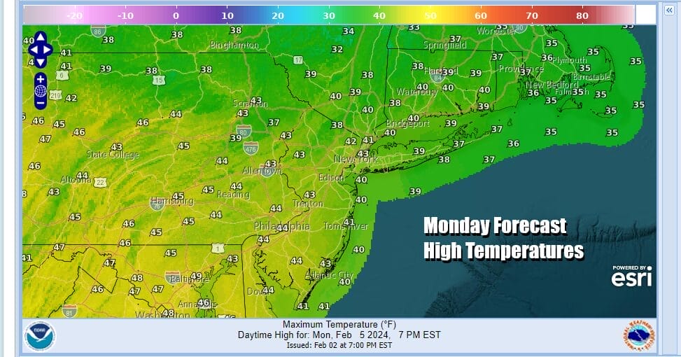
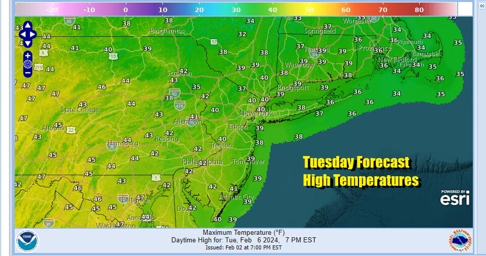
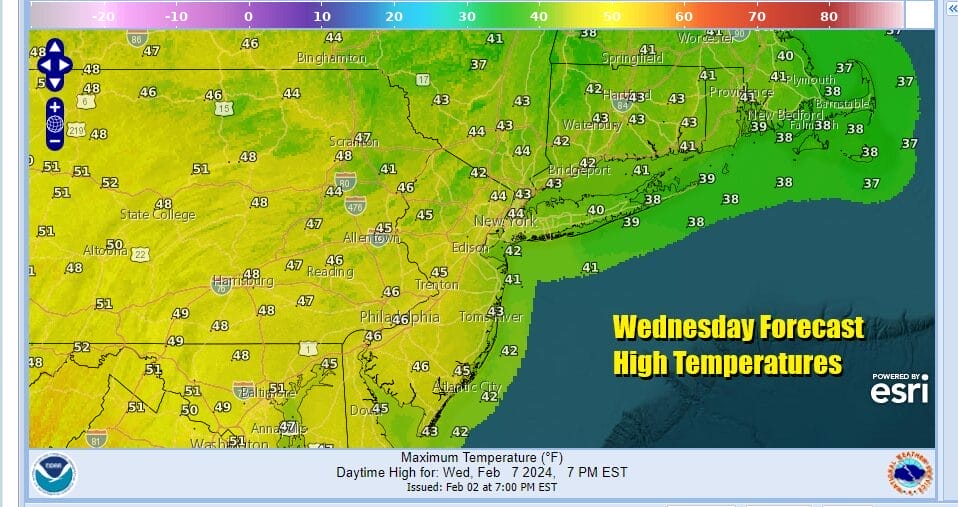
 Nights over the next several days will be cold and mostly clear. Lows will be mainly in the 20s except for lower 30s warmer urban lcoations. Monday looks to be a nice sunny day with highs in the low to mid 40s. Tuesday we are looking at another day of sunshine. Highs will be a little lower, in the upper 30s and lower 40s. We could say the same for Wednesday as the high still holds on. Sunny skies are forecast with highs again in the upper 30s and lower 40s.

Thursday brings warmer air on a southwest wind and we should still be seeing some sunshine. Highs will be in the mid 40s to around 50 degrees. Friday will be nice and mild with clouds and perhaps the chance for a shower or two, though it is possible that the next weather front comes through dry. Friday highs will be in the 50s.
BE SURE TO DOWNLOAD THE FREE METEOROLOGIST JOE CIOFFI WEATHER APP &
ANGRY BEN'S FREE WEATHER APP "THE ANGRY WEATHERMAN!
MANY THANKS TO TROPICAL TIDBITS FOR THE USE OF MAPS
Please note that with regards to any severe weather, tropical storms, or hurricanes, should a storm be threatening, please consult your local National Weather Service office or your local government officials about what action you should be taking to protect life and property.(Amazon is an affilate of Meteorologist Joe Cioffi & earns commissions on sales.)